
 Yahoo Finance
 Solstice Commences 5,000m Drill Program at its Red Lake Extension Provides Details of Summer Target Areas

Figure 1
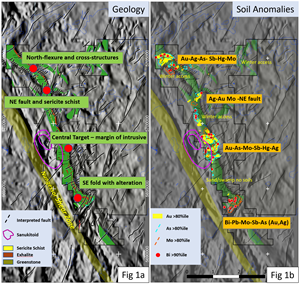
Figure 2
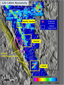
Figure 3
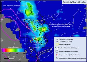
Figure 4

Figure 5
VANCOUVER, British Columbia, June 21, 2022 (GLOBE NEWSWIRE) -- Solstice Gold Corp. (TSXV: SGC) (“Solstice”, “we”, “our” or the “Company”) is pleased to announce the commencement of Phase 1 drilling at its 100% owned, Red Lake Extension (“RLX”) project, located in the northwestern corner of the prolific Red Lake Gold Camp (the “Camp”). The 5,000m (10-15 drill hole program) will test three main target areas at an average depth of ~250m below surface. The target areas outlined in this news release are the initial or summer target areas and exclude winter-accessible areas of the project.
Mike Timmins, Solstice CEO stated, “After a year of systematic technical work by our team, we are excited to reveal several well-developed drill targets which further demonstrate the potential of the property. We will test this potential with the current drill program and continue to leverage our technical edge, as we embark on a campaign to explore, for the first time, 16km of prospective gold-bearing structure in Red Lake. Vital Drilling, based in Sudbury has commenced drilling at the Central Target, a milestone that marks an exciting time for Solstice shareholders ahead of what we anticipate being a catalytic second half of 2022.”
Background
RLX hosts a road-accessible, 16km-long largely unexplored extension of the Red Lake Greenstone Belt (“RLGB”), located ~27 km north of the community of Red Lake. It lies in the vicinity of a major deep-tapping fault inferred by government geologists and researchers from seismic data1,2. Mapping by the Ontario Geological Survey (“OGS”)3 has identified a regional scale mylonite zone, the Nungessor Shear Zone (“NSZ”) which parallels the property to the west. In the western part of the RLX project, a distinctive intrusive rock type known as ‘Sanukitoid’ has also been mapped by government geologists. Such intrusions are derived from deep (mantle) sources and are typically associated with major crustal-scale faults. The Ontario Geological Survey1 has noted from seismic data that, elsewhere in Red Lake, important gold deposits are associated with these deep-tapping structures. We consider the geological and structural setting at RLX to be highly prospective for gold mineralization.
“We believe that our RLX project has all the attributes to host gold mineralization in a gold camp that continues to yield new gold discoveries. Our focused and integrated exploration program has identified several compelling and significantly sized target areas, which we look forward to testing with our first drill program in this area of the Camp.” stated Solstice Chairman, David Adamson.
A technical review of these initial drill targets narrated by David Adamson is available here as well as on the Company’s website.
Programs to Date and Key Observations at RLX
Much of the property is covered by overburden. To develop targets, Solstice has carried out a systematic exploration program consisting of mapping, airborne magnetic and electromagnetic (“EM”) surveys as well as humus soil sampling. The following summarizes the key findings of these programs (See also Figures 1a-b and 2):
Greenstone at RLX is present or inferred over a 16km strike length (Fig 1a), parallel to the regionally mapped Nungessor Shear Zone (NSZ).
The entire sequence is cut by several prominent fault sets (Fig 1a). Some of these may splay off the NSZ while others (NE set) can be traced southwestwards to the main RLGB and the Sidace Gold Deposit (Evolution Mining 53.3% / Pacton Gold 46.7%)
Greenstones form a keel between the NSZ and granitic rocks to the east and are intruded by one or more Sanukitoid bodies (Fig 1a).
Strong gold and pathfinder element soil signatures are developed in several locations across the property (Fig 1b). The most prominent of these, the Central Target Area, outlines a 2km x 0.9km target area that is adjacent to the eastern margin of the main mapped Sanukitoid (Figs 1a and 1b).
Airborne EM surveys define several conductive target areas and, in general, display increasingly conductive responses with depth (Fig 2).
Figure 1 is available at:
https://www.globenewswire.com/NewsRoom/AttachmentNg/0930e562-14ef-4654-8001-b553395f0a11
Drill Target Areas
Three main targets areas described below, will be tested by upcoming diamond drilling (see Figure 2). In order of priority, these areas are:
Central Target
South Fold Target
North-Central Target
Figure 2 is available at:
https://www.globenewswire.com/NewsRoom/AttachmentNg/d62e8040-93f4-44fe-8d73-ebc7572befeb
Central Target
Figure 3 outlines proposed drill holes designed to test a 2km x 0.9km target area that demonstrates a close spatial relationship between:
Elevated soils (Au plus several pathfinder elements)
The outline of areas of moderate to low resistivity as shown by the 140-160m vertical conductivity slice from the EM SCI 1D inversion model
The mapped margin of the Sanukitoid intrusive.
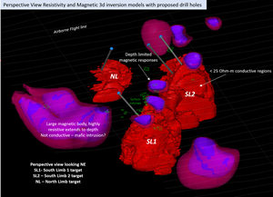
These features are also shown in a perspective 3D view in Figure 4.
Proposed drill holes at the Central Target are designed to test geology, gold in soils and EM horizons at a vertical depth of approximately 150m below surface.
Figure 3 is available at:
https://www.globenewswire.com/NewsRoom/AttachmentNg/f78575e5-d9a7-431b-8cc5-06f21fd8bf59
South Fold Target
This area is defined by a NE trending fold cut by regional-scale NE-faults. Mapping in this area has identified epidote and carbonate layered mafic volcanic flows and flow breccias with local intercalated exhalite units. These are likely correlated to mafic volcanics in the main RLGB. The area exhibits strong Bi-Pb-Mo and Au-Ag-Sb soil anomalies. EM inversion modeling identifies three main target areas which display increasing conductivity with depth. Drilling in this area (Figure 5) is designed to test all three attributes, geological, geochemical, and geophysical.
North-Central Target
Drilling in this area will test across an area of well-developed Ag-Sb-As and Au-Mo soil anomalies which likely overlay, in part, sericite schist which was partially intersected at the top of a 1980 drill hole located approximately 250m to the north. Sericite schist is one of the key target units of our exploration model in this area and our drilling is designed to drill across the target sequence and elevated soils. The target area is also cut by a regional-scale NE fault which will also be tested by the proposed drill holes. Weakly conductive EM responses are noted in this area which would is consistent with a target which may contain minor sulphides within units that include sericite schists.
Figure 4 is available at:
https://www.globenewswire.com/NewsRoom/AttachmentNg/16d57fc4-8eee-4c89-8222-c7c5e13937a1
Figure 5 is available at:
https://www.globenewswire.com/NewsRoom/AttachmentNg/fe0096c2-c67a-4194-9baf-7bd7ff83017f
Data Sources and References
Magnetic and EM data referred to in this report were derived from a 75m-spaced SkyTEM heliborne survey carried out in late 2021. Inversions of magnetic data were carried out by In3D Geosciences of BC, Canada using the UBC 3D inversion model. EM inversion models were prepared by Emergo (Aarhus Geophysics) of Denmark following the removal of airborne IP effects in the original SkyTEM data. Examples shown in this release are from the Spatially Constrained Inversion model.
While Solstice worked with the above consultants to generate these products, all targets and interpretations in this news release are those of Solstice Gold.
Mapping and soil sampling was carried out by S. Barham, P.Geo., Senior Geological Consultant to Solstice.
Soils data, QA/QC and methodologies have been reported previously. Soil data referenced in this release are summarized in the table below (see news release dated March 14, 2022):
Statistic | Au ppb | Bi ppm | As ppm | Mo ppm | Ag ppm | Sb ppm | Hg ppb |
Nbr. of observations | 711 | 711 | 711 | 711 | 711 | 711 | 711 |
Minimum | 0.05 | 0.01 | 0.05 | 0.04 | 0.005 | 0.01 | 1 |
Maximum | 19.70 | 1.39 | 48.60 | 5.22 | 0.975 | 24.60 | 420 |
1st Quartile | 1.20 | 0.09 | 3.60 | 0.24 | 0.036 | 0.10 | 80 |
Median | 2.00 | 0.12 | 5.30 | 0.36 | 0.066 | 0.17 | 120 |
3rd Quartile | 3.30 | 0.17 | 7.80 | 0.51 | 0.127 | 0.29 | 190 |
Mean | 2.66 | 0.14 | 6.28 | 0.46 | 0.098 | 0.25 | 135 |
Variance (n-1) | 6.43 | 0.01 | 18.71 | 0.22 | 0.010 | 0.87 | 6197 |
Standard deviation (n-1) | 2.53 | 0.09 | 4.33 | 0.47 | 0.102 | 0.93 | 79 |
|
|
|
|
|
|
|
|
Note that drill holes portrayed in this news release are proposed holes. Actual drill holes may vary due to results, budgets and possible access issues.
Please refer to our website at www.solsticegold.com for additional details.
1Lewis, S.O. 2021. Deep tapping seismic structure in the Red Lake district; in Ontario Geological Survey, Resident Geologist Program, Recommendations for Exploration 2020-2021, p.9-13.
2 Calvert, Andrew J. and Cruden, Alexander R. 2004. Seismic evidence for the preservation of the Archean Uchi granite-greenstone belt by crustal-scale extension. Tectonophysics 388 p.135-143
3 Stone, D. and Good D. 1990. Precambrian geology, Nungesser Lake; Ontario Geological Survey, Preliminary Map P.3175, scale 1:50000.
About Solstice Gold Corp.
Solstice is an exploration company with quality, district-scale gold projects in established mining regions of Canada. Our 180 km2 Red Lake Extension (RLX) and New Frontier projects are located at the northwestern extension of the prolific Red Lake Camp in Ontario and approximately 45km from the Red Lake Mine Complex owned by Evolution Mining. The Company is funded for phase one drilling at RLX. Our newly formed 322km2 Atikokan Gold Project is approximately 23km from the Hammond Reef Gold Project owned by Agnico Eagle Mines Limited and is fully funded for a robust field program in 2022. Our Qaiqtuq Gold Project which covers 886 km2 with certain other rights covering an adjacent 683 km2, hosts a 10 km2 high grade gold boulder field, is fully permitted and hosts multiple drill-ready targets. Qaiqtuq is located in Nunavut, only 26 km from Rankin Inlet and approximately 7 km from the Meliadine Gold Mine owned by Agnico Eagle Mines Limited. An extensive gold and battery metal royalty and property portfolio of over 80 assets was purchased in October 2021. Approximately $1.2 million in value and two new royalties have been generated since the acquisition.
Solstice is committed to responsible exploration and development in the communities in which we work. For more details on Solstice Gold, our exploration projects and details on our recently acquired portfolio of projects please see our Corporate Presentation available at www.solsticegold.com.
David Adamson was a co-award winner for the discovery of Battle North Gold Corporation's Bateman Gold deposit and was instrumental in the acquisition of many of the district properties in the Battle North portfolio during his successful 16 years of exploration in the Red Lake.
Sandy Barham, M.Sc., P.Geo., Senior Geologist, is the Qualified Person as defined by NI 43-101 standards responsible for reviewing and approving the technical disclosures of this news release.
Neither TSX Venture Exchange nor its Regulation Services Provider (as that term is defined in the policies of the TSX Venture Exchange) accepts responsibility for the adequacy or accuracy of this release.
On Behalf of Solstice Gold Corp.
Mike Timmins, Chief Executive Officer
For further information on Solstice Gold Corp., please visit our website at www.solsticegold.com or contact:
Phone: (604) 283-7234
Forward-Looking Statements and Additional Cautionary Language
This news release contains certain forward-looking statements (“FLS”) including, but not limited to three main target areas for Phase 1 drilling at RLX including the location of proposed drill holes, prospective gold mineralization at RLX, and drilling planned across the target sequence and elevated soils at the North-Central target area. FLS can often be identified by forward-looking words such as “approximate or (~)”, “emerging”, “goal”, “plan”, “intent”, “estimate”, “expects”, “potential”, “scheduled”, “may” and “will” or similar words suggesting future outcomes or other expectations, beliefs, plans, objectives, assumptions, intentions or statements about future events or performance. There is also no guarantee that continued exploration at Solstice exploration projects, all of which are at an early stage of exploration, will lead to the discovery of an economic gold deposit. Factors that could cause actual results to differ materially from any FLS include, but are not limited to, unforeseen delays related to drilling, the future impacts of the COVID 19 pandemic and government response to such pandemic, the ability of the Company to continue exploration at its projects during the pandemic and the risk of future lack of access to the projects as a result thereof, delays in obtaining or failures to obtain required TSXV, governmental, environmental or other project approvals, potential relocation of targeted drill holes due to budgets and/or access issues, inability to locate source rocks, inflation, changes in exchange rates, fluctuations in commodity prices, delays in the development of projects, regulatory approvals and other factors. FLS are subject to risks, uncertainties and other factors that could cause actual results to differ materially from expected results.
Potential shareholders and prospective investors should be aware that these statements are subject to known and unknown risks, uncertainties and other factors that could cause actual results to differ materially from those suggested by the FLS. Shareholders are cautioned not to place undue reliance on FLS. By their nature FLS involve numerous assumptions, inherent risks and uncertainties, both general and specific, that contribute to the possibility that the predictions, forecasts, projections and various future events will not occur. Solstice undertakes no obligation to update publicly or otherwise revise any FLS whether as a result of new information, future events or other such factors which affect this information, except as required by law.
This news release contains information with respect to adjacent or other mineral properties in respect of which the Company has no interest or rights to explore or mine or acquire. Readers are cautioned that mineral deposits on adjacent or similar properties are not indicative of mineral deposits on the Company’s properties, nor is there certainty that Solstice’s projects will contain economic mineralization. This news release mentions other companies that are unrelated to Solstice, and this does not imply any agreements, partnerships, or rights with respect to any of these companies or their properties other than where explicitly defined. Past performance is no guarantee of future performance, and all investors are urged to consult their investment professionals before making an investment decision.

