
 Yahoo Finance
 Greenridge Exploration Provides Technical Review of its Nut Lake Uranium Project in Thelon Basin, Nunavut

VANCOUVER, British Columbia, April 04, 2024 (GLOBE NEWSWIRE) -- Greenridge Exploration Inc. (“Greenridge” or the “Company”) (CSE: GXP | FRA: HW3), is pleased to announce it has undertaken a detailed technical review of the Nut Lake Uranium Project (the “Nut Lake Property” or the “Project”) located in the Thelon Basin in Nunavut. The Project covers approximately 4,036 hectares near the Northern Tip of the Yathkyed Basin, a sub-basin of the Thelon Basin (Please see Figure 1).
Russell Starr, Chief Executive Officer of the Company, commented, “We continue to unveil more exciting geological information at the Nut Lake Uranium Project. The Thelon Basin and sub basins are extremely underexplored compared to the world renowned Athabasca Basin just to the south. With a sound database of historical work, including both high grade surface sampling and near surface drilling, it is giving us a clear route to build upon the historical success using new technology and expanding on our deposit model.”
Historical Showings, Geology & Various Surveys Completed at The Nut Lake Property
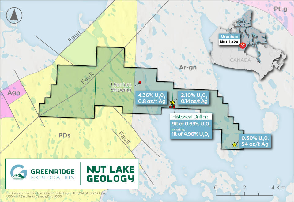
Figure 1 – Localized Nut Lake Property Geology Map. Source GSC Open File 4236. Abbreviations: PDs – Proterozoic Dubawnt Sediments, Agn / Ar-gn – Archean granitic rocks, Pt-g – Undivided Granites
Historical Showing Highlights
Historical exploration undertaken by Pan Ocean in 1979 conducted over the large regional grid resulted in the discovery of four prospects/showings on the Nut Lake Property (Please see Figure 1).
Tundra Showing
Discovered in July 1977 and named the Tundra showing due to its proximity to a syenite U3O8 anomaly on the lakeshore.
Hole Winkie AX W-24 intersected 9ft of 0.69% U3O8 including 4.90% U3O8 over 1ft from 8ft depth¹.
Drilling extended the depth of mineralization to 20 feet vertically below the surface.
The structure appears to steepen with depth to about 80-85°.
A total of 17 holes amounting to 568 ft. of drilling were completed.
Heartbreak and Lakeshore Showings
The Heartbreak showing uncovered two pitchblende fractures in an area where a swarm of biotite trachyte occurs, 200 meters to the east-southeast of the Tundra showing.
The most noteworthy samples were from the Heartbreak showing which returned samples across a 3.0” and 3.5” fracture that assayed 2.11% U3O8 and 4.36% U3O8 respectively.
Fracture descriptions and assay results indicate significant mineralization potential.
Frost heave on the surface suggests a potential strike length for the fractures.
Lake Showing
Two noteworthy grab samples yielded 0.32% and 0.15% U3O8.
The Lake showing was located through general prospecting and is situated beside a biotite feldspar trachyte dike.
It comprises numerous anomalous fractures containing chloritic mafic alterations, sulphides, hematite, and uranium mineralization.
Some fractures cut across the felsic to mafic gneiss host rock, while others run subparallel to it.
This suggests that the mineralization and alteration may be controlled by fractures, with a foliation influence. It is likely that some of these fractures extend into the water.
Geology of The Nut Lake Project
Regionally, the Project lies along the eastern edge of the northeasterly trending wedge of Paleohelikian or Late Aphebian Dubawnt Group rocks and the contact with Archean basement gneisses. These units are in fault contact along a northerly trending fault zone. Dubawnt Group rocks within the area are basal sedimentary rocks of the South Channel Formation, composed of white quartzites and pink to grey arkose and arkosic rocks. The sedimentary sequences of the lower Dubawnt Group are overlain by volcanic rocks of the Christopher Island Formation, including trachytic lithic and crystal tuffs and mafic to felsic trachyte flows.
Archean gneisses are generally granitic to granodioritic in composition, with thin inter-layered bands of paragneiss or amphibolite. Syenites within the area are predominantly red, aphanitic, microsyenite, with some hornblende syenite locally. Microsyenite dikes intrude all other rock types along a northerly trend, exhibiting varying degrees of brecciation, especially near fault zones. These rocks contain variable amounts of magnetite, chlorite, disseminated hematite, and pyrite, with accessory zircon noted. The microsyenites are the most radioactive rocks in the area, containing an average of 100 ppm U, with uranium believed to be bound up in refractory minerals¹ (Please see Figure 1).
Surveys Completed at the Nut Lake Project
An abundance of both Government and industry geological / geophysical / hyperspectral surveys have been conducted over the Project area including: a regional residual magnetic geophysical survey conducted by the Geological Survey of Canada in 20113; a property scale VLF-EM and Magnetometer survey carried out by Pan Ocean in 1979¹; and a hyperspectral survey carried out in 2023 by the vendors of the Project.
Lines for the 1979 geophysical surveys were spaced 100m apart with 24m to 50m station intervals.
VLF-EM Survey
Several interesting anomalies resulted from the survey including a pattern indicating a north-northwesterly trending structure of interest.
Anomalies are likely related to a fault zone, continuous with a VLF-EM anomaly.
A major anomaly was identified from “L14W to L2S and 14E to 19E”. This anomaly is not known to be related to any specific feature and should be followed up on.
Identification of north trending anomalies which may be related to structural or lithological features.
Magnetometer Survey
Magnetic anomalies show less distinct north to northwesterly trends compared to VLF-EM map.
Anomalies in northwest section related to syenitic intrusive rocks.
Irregular pattern in this area possibly due to close-spaced dikes and lenses of mafic gneiss.
A gravity survey is recommended to pair with both surveys moving forward.
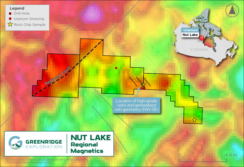
Figure 2 - Regional Magnetics showing a strong NE-SW trending Fault3
Hyperspectral Survey
Helium is a decay product of Uranium and is an exploration vector for buried uranium deposits. Helium is released as a “daughter” product of radioactive decay as uranium breaks down into other elements. As helium is a very light element it migrates through the overburden and into the atmosphere. Where the release of helium is concentrated enough, it will have a spectral signature in specific wavelengths that can be seen by satellite sensors. These are in the Visible-Near Infra-Red (VNIR) and Short Wave Infra-Red (SWIR) wavelengths parts of the spectrum. The Sentinel-2 satellite data contains spectral bands which can be processed to identify areas with an anomalous helium spectral signature. A stronger spectral signature in the helium wavelength could be due to a buried radioactive source (Please see Figure 3).
The survey identified 2 clusters with anomalous spectral responses that are coincident with a northeast-trending structure identified by geophysical surveys.
These two target areas have not historically seen extensive exploration, and therefore warrant ground truthing to explain the helium response.
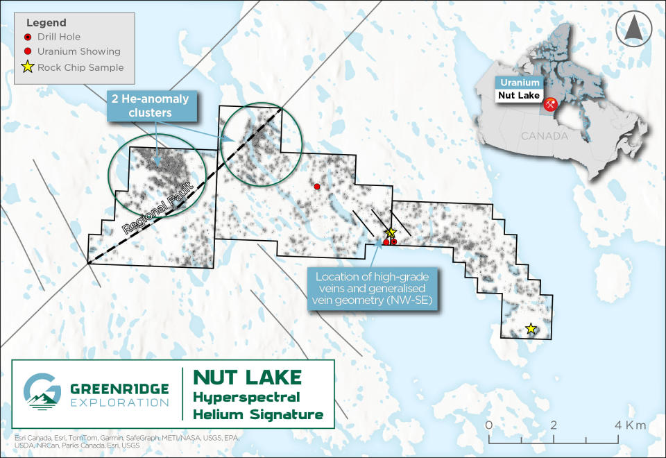
Figure 3 - Hyperspectral Survey
About The Nut Lake Property
The Project is located approximately 55km north of the Angulak Uranium Deposit² or 180Km southwest of Baker Lake, Nunavut in the Yathkyed Basin (a sub-basin of the prolific Thelon Basin) in Nunavut Territory, Canada. The Project consists of three contiguous mineral licences encompassing a total land area of approximately 4,036 hectares (~40km²).
In 1979, Pan Ocean Oil Ltd. performed an exploration program consisting of ground geophysics, geological mapping, prospecting and Winkie drilling as follow up to previous sampling with elevated uranium in dyke swarms, fractures and contacts between syenites and trachytes. The geology of the Project area consists of basal sedimentary rocks of the South Channel Formation, composed of white quartzites and pink to grey arkose and arkosic rocks. The sedimentary sequences of the lower Dubawnt Group are unconformably or disconformably overlain by volcanic rocks of the Christopher Island Formation.
The Project hosts high grade vein hosted grab samples of up to 4.36% U3O8, 53.16 oz/t Ag, 1.15% Pb and 7.0% Ni¹.
During the 1979 field season, geological mapping at a scale of 1:1,000 was completed on a major portion of the Project. This was concurrent with prospecting on, and in the immediate area of the Project. Results from prospecting were the discovery of two (41 m wide) syenite dikes and a frost heaved area of felsic gneiss with up to 3,000 cps on fracture surfaces. Two significant Uranium bearing showings were discovered, the “Lake Showing” and the “Heartbreak Showing”. The most noteworthy was the Heartbreak showing which revealed 3.0” and 3.5” samples across a fracture that assayed 2.11% U3O8 and 4.36% U3O8 respectively. The results were followed up with a radon gal survey, a VLF-EM survey and an overburden sampling program. The radon survey results showed that the response is irregular with several good highs and the VLF-EM survey showed a series of northwesterly trending anomalies. It was concluded that further drilling of the Lake Showing is recommended.
The Project and surrounding proximal area have seen approximately 805ft of Winkie Drilling and 6920ft of diamond drilling completed on it. Multiple holes intersected significant uranium mineralization, with the most noteworthy being at the “Tundra Showing” Hole Winkie AX W-24 intersected 9ft of 0.69% U3O8 including 4.90% U3O8 over 1ft from 8ft depth¹. Additional noteworthy holes were hole P049 which returned approximately 0.20% U3O8 over a one-foot interval and hole 068 which was Drilled to intersect fracture mineralization and successfully encountered approximately 0.59% over 1 foot. (Pan Ocean Oil Ltd., 1979 Assessment Report #81075).
The combination of historically defined anomalies and modern exploration techniques provides prime ingredients for the potential of discovering a high-grade uranium system within the Project area. The Nut Lake Property has the potential to host unconformity vein and breccia type, sygenentic and sandstone-hosted phosphatic type mineralization.
References
1Source: 1978 Assessment report (number 81075) by Pan Ocean Oil Ltd
2Source: Reported by ValOre Metals Corp. in a Technical Report entitled “Technical Report and Resource Update For The Angilak Property, Kivalliq Region, Nunavut, Canada”, prepared by Michael Dufresne, M.Sc., P.Geo. of APEX Geosciences, Robert Sim, B.Sc., P.Geo. of SIM Geological Inc. and Bruce Davis, Ph.D., FAusIMM of BD Resource Consulting Inc., dated March 1, 2013. Note: The historical mineral resource estimate was calculated in accordance with NI 43-101 and CIM standards at the time of publication and predates the current CIM Definition Standards for Mineral Resources and Mineral Reserves (May, 2014) and CIM Estimation of Mineral Resources & Mineral Reserves Best Practices Guidelines (November, 2019).
3Source: Tschirhart, V. L., Morris, W. A. & Oneschuk, D. (2011). Geophysical series, geophysical compilation project, Thelon Basin, Nunavut, NTS 66A, B, and parts of 65N, O, P, 66C, F, G and H. Geological Survey of Canada, Open File, 6944, https://doi.org/10.4095/288806.
4Source: Wilkinson, L. & Brown, N. (2000). Selected geoscience data from the Western Churchill NATMAP Project, Kivalliq Region, Nunavut - Volume II. Geological Survey of Canada, Open File, 3749, https://doi.org/10.4095/211855.
National Instrument 43-101 Disclosure
Nicholas Rodway, P. Geo, (NAPEG Licence # L5576) is a qualified person as defined by National Instrument 43-101- Standards of Disclosure for Mineral Projects. Mr. Rodway has reviewed and approved the technical content in this release.
About Greenridge Exploration Inc.
Greenridge Exploration Inc. (CSE: GXP | FRA: HW3) is a mineral exploration company dedicated to creating shareholder value through the acquisition, exploration, and development of critical mineral projects in North America. The Company’s Nut Lake Uranium Project located in the Thelon Basin includes historical drilling which intersected up to 9ft of 0.69% U3O8 including 4.90% U3O8 over 1ft from 8ft depth¹. Additionally, the Company’s Weyman Copper Project in southeast British Columbia sits on the south portion of the famous Quesnel Terrance. The Company is led by an experienced management team and board of directors with significant expertise in capital raising and advancing mining projects.
On Behalf of the Board of Directors
Russell Starr
Chief Executive Officer, Director
Telephone: +1 (778) 897-3388
Email: info@greenridge-exploration.com
Disclaimer for Forward-Looking Information
This news release contains certain forward-looking statements within the meaning of applicable securities laws. All statements that are not historical facts, including without limitation, statements regarding future estimates, plans, programs, forecasts, projections, objectives, assumptions, expectations or beliefs of future performance, including statements regarding the project acquisition bringing a low-risk opportunity, the Company, building a strong battery metals portfolio with low-risk opportunities that positively impact the Company and its shareholders and the Company providing an initial work plan are "forward-looking statements". Forward-looking statements in this news release include, but are not limited to, statements with respect to the Project and its mineralization potential; the Company’s objectives, goals, or future plans with respect to the Project; and the Company's anticipated exploration program at the Project. These forward-looking statements reflect the expectations or beliefs of management of the Company based on information currently available to it. Forward-looking statements are subject to a number of risks and uncertainties, including those detailed from time to time in filings made by the Company with securities regulatory authorities, which may cause actual outcomes to differ materially from those discussed in the forward-looking statements. These factors should be considered carefully, and readers are cautioned not to place undue reliance on such forward-looking statements. The forward-looking statements and information contained in this news release are made as of the date hereof and the Company undertakes no obligation to update publicly or revise any forward-looking statements or information, whether because of new information, future events or otherwise, unless so required by applicable securities laws.
The Canadian Securities Exchange (CSE) does not accept responsibility for the adequacy or accuracy of this release.
Photos accompanying this announcement are available at:
https://www.globenewswire.com/NewsRoom/AttachmentNg/bdf3181c-fde3-418c-aa13-f6a65418acf2
https://www.globenewswire.com/NewsRoom/AttachmentNg/5beffd94-303b-4074-bbf6-a18fc0793b5f
https://www.globenewswire.com/NewsRoom/AttachmentNg/571bbdc4-e39c-4c01-9c0b-ff0377361aaa

