
 Yahoo Finance
 Flooding hits Erie Shore Drive, Thames River in Chatham-Kent
This week's massive rainfall and high winds have translated into flooding for Erie Shores Drive and inland on the Thames and Sydenham rivers in Chatham-Kent.
The Lower Thames Valley Conservation Authority (LTVCA) and The St. Clair Region Conservation Authority have placed the areas under flood warnings.
"Many local watercourses have reached bank full conditions or spilled their banks," the LTVCA said in its warning. "High water on some watercourses should still be expected over the next couple of days, especially in downstream areas that might be influenced by high water on the Thames River."
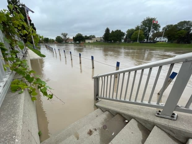
The conservation authority said that the sidewalk along the Thames in Chatham is expected to be flooded.
With a chance of showers in the forecast for Friday, and rain Saturday, it said floodwaters are expected to hit several streets in downtown Chatham and flood basements of businesses along King Street this weekend.
On flood-prone Erie Shore Drive, high winds have caused water build-up on properties and onto the roadway in some locations. People are being asked to avoid the area.
Jason Homewood, water management supervisor with the LTVCA, said wind speed plays a big role in flooding. Over the last few years, he said the speed has reduced from 60 km per hour to 30 km per hour before water rises and flooding begins.
"We were out there earlier this week when the winds had reached 35 km per hour and the waves were starting to come over the break walls and pool up into people's yards and get onto the road," Homewood said.
Homewood said winds are expected to climb to 45 km/h on Thursday, therefore he predicts flooding will continue into the evening.
On Wednesday, Environment Canada issued a rainfall warning for Windsor-Essex and Chatham-Kent, with 75 to 100 millimetres expected by Thursday morning.
The current forecast suggests a 30 per cent chance of showers for Thursday evening.
Despite the region's flooding, Homewood said lake levels have dropped this year.
He estimates the lake levels are six to seven inches below levels recorded in 2020, which was a record setting year for high water levels.
LISTEN | Jason Homewood, water management supervisor discusses flooding in Chatham-Kent
As for flooding, Homewood predicts it will continue throughout Thursday on Erie Shore Drive.
Water levels rose and flooding also occurred in multiple regions just on the outskirts of Sarnia on Wednesday night.
According to the St. Clair Region Conservation Authority, more than 115 millimetres of rain fell over the past two days leading to flooding and road closures.
In a statement, the conservation authority reported high levels of water throughout the region and flooding in the upper reaches of the Sydenham River.
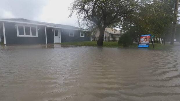
Parks, farmland and floodplain areas in Strathroy, Alvinston, Brigden and Florence experienced exceedingly high water levels.
The authority said a long list of roads are flooded or expected to be affected.
In Essex County, the Essex Region Conservation Authority has issued a watershed conditions statement due to elevated water levels. The statement will remain in effect until noon on Saturday, Sept. 25, ERCA says. The area and its shoreline were previously under a flood watch, which is a stronger warning, and the watch remains in effect for Lake Erie.
