
 Yahoo Finance
 Tropical Storm Ian forms, expected to become a hurricane before hitting Cuba, then Florida
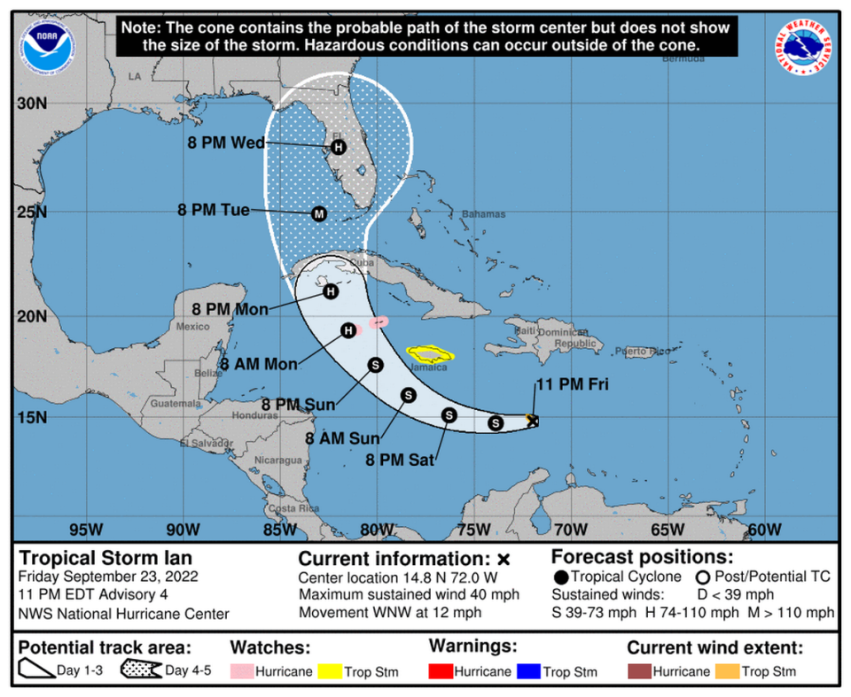
Tropical Storm Ian formed late in the Caribbean Sea late Friday night, becoming the ninth tropical storm of the 2022 Atlantic season. Its current trajectory has it making landfall in Cuba early next week and then possibly Florida, potentially striking the sunshine state as a Category 3 hurricane.
Where Ian will land and how much of the state it will affect is still unclear, as nearly all of the state remains in the storm’s cone of concern, as of the National Hurricane Center’s 11 p.m. advisory. The center of the cone has shifted farther into Florida near Tampa, but forecasters warn this could change. Ian could also become stronger than the current forecast.
Gov. Ron DeSantis declared a state of emergency for 24 counties potentially in the storm’s path, including Miami-Dade, Broward, Monroe and Palm Beach. That move will open up resources and support for regions that might face serious impact.
READ MORE: Miami-Dade, other counties under state of emergency as storm grows. Here’s what it means
Earlier Friday it appeared the new storm would be called Hermine, but another system in the suddenly active tropics beat it to that name.
Officials say to start hurricane prepping
Jamie Rhone, acting director of the National Hurricane Center, told Floridians it is time to check hurricane supplies and top off gas tanks, but warned that it was too soon to know exactly where or how the storm could affect the state.
“I’m a Floridian too so I’m going to speak to you candidly. Don’t panic,” he said. “We are still in the early stages of this event.”
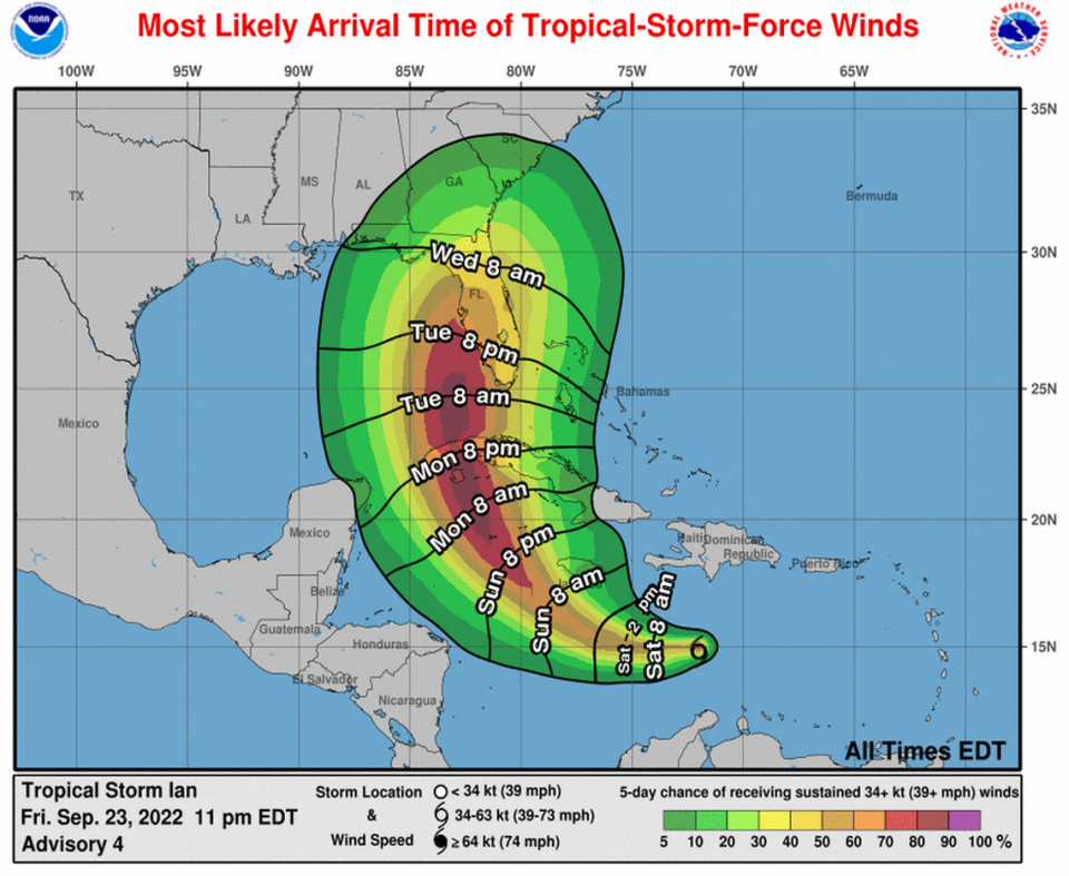
At five days out, the hurricane center’s error cone is nearly 400 miles wide, and the forecast could shift in the next few days for where the center of the storm makes landfall and where its effects will be felt.
READ MORE: Florida is in the cone. What it means for you and what you should be doing
South Florida and the Keys need to have preparation done by Monday night, Rhone said. On the current track, South Florida could see winds starting to pick up Tuesday night, although that could change.
“We have a lot of time. This forecast can and will evolve,” he said. “It is important that you take this threat seriously.”
Both Miami-Dade County and Monroe County are monitoring the progress of the storm and urged residents to be prepared but not panic.
READ MORE: Will the Keys have to prepare for a storm? What about evacuations? What we know so far
Where is the storm now?
On Friday night, Ian was moving slower than earlier in the day but the wind shear it was battling will soon decrease and the storm will be moving toward “very warm waters,” which may cause intensification, the hurricane center said.
The 11 p.m. advisory put the storm about 385 miles southeast of Kingston, Jamaica, and about 680 miles east-southeast of Grand Cayman. It had 40 mph maximum sustained winds and was moving west-northwest at 12 mph.
Its tropical-storm-force winds extended outward up to 35 miles from its center.
Ian is expected to keep moving west or west-northwest in the Caribbean over the weekend as a tropical storm, and then turn toward the north-northwest by late Monday.
The hurricane center’s latest forecast suggests those conditions could boost the tropical storm into a Category 2 hurricane with 110 mph winds as it crosses Cuba and heads toward Florida, where it is projected to strengthen into a Category 3 storm with 115 mph winds.
READ MORE: What those hurricane spaghetti models all over social media actually mean
“The track models agree on this general scenario,” the center’s 11 p.m. advisory read, noting that its prediction was in the center of that guidance.
Forecasters warned that Ian could see “rapid intensification” as it moves over the northwestern Caribbean toward western Cuba. Ian won’t be over Cuba long enough to weaken much and is expected to Florida’s west coast as a major hurricane.
What the spaghetti models show
[#MeteorologyAnalysis] Let's take a deeper look into the forecast track uncertainty with Tropical Depression 9.
The majority of ensemble members can be generally split into 2 scenarios:
- TD #9 quickly recurves & tracks up East Coast
- TD #9 slows down in eastern Gulf pic.twitter.com/kLETH1evCq— Tomer Burg (@burgwx) September 23, 2022
Jackson Dill, a meteorologist for WSVN news, said two major hurricane models show different paths once the storm nears Cuba. The European model calls for a faster storm that moves closer to South Florida, while one known as GFS predicts a slower-moving storm that tends toward northern Florida.
We're still looking at two scenarios right now with Tropical Depression Nine.
Scenario 1: The storm tracks more to the southwest and is slower, bringing it farther north toward Florida next week.
Scenario 2: It tracks quicker and more northeast, bringing it closer to SoFlo. pic.twitter.com/p4raBIEAdM— Jackson Dill (@Jackson_Dill) September 23, 2022
Friday afternoon models continue to point toward a southwest Florida landfall but edged west, more toward Sarasota and away from Fort Myers. This windshield-wiper back and forth will likely continue through the weekend as the storm strengthens and the computer models do a better job of tracking it.
The latest ECMWF weather model tracks for TD9 https://t.co/4QEEkHvAuR pic.twitter.com/0Bmp8epRHG
— ECMWFbot (@ECMWFbot) September 23, 2022
Caribbean to see hurricane, tropical storm conditions
The Cayman Islands issued a hurricane watch Friday evening, and Jamaica issued a tropical storm watch. Both are expected to see about 4 to 8 inches of rain, and as much as a foot in some areas.
In the Cayman Islands, residents were warned to be prepared for loss of power and to expect flooding in low-lying areas on the island of Grand Cayman. All government offices closed at 3 p.m. Friday.
Tropical storm conditions are possible in the Cayman Islands by late Sunday, with hurricane conditions possibly beginning early Monday.
“I ask that you remain calm,” Premier Wayne Payton said in an address to the British Overseas Territory. “Preparation and caution are key to remaining safe. Please conclude your preparations as quickly as possible and plan to be safely sheltered by Sunday afternoon.”
The island’s shelters will open at 2 p.m. on Sunday. Payton said the government has authorized supermarkets, hardware stores and Home Depots to be open for business on Sunday from 6 a.m. to 4 p.m. so residents can make final preparations.
In Jamaica, residents were warned that the island could experience heavy rain. Tropical storm conditions could start to affect Jamaica by Sunday.
“These rains may produce flash flooding and mudslides in areas of higher terrain, particularly over Jamaica and Cuba,” the hurricane center said.
Forecasters say parts of western and central Cuba could get 6 to 10 inches of rain, with some areas getting as much as 14 inches.
The southern areas of Haiti and the Dominican Republic could see two to four inches of rain, with some areas perhaps getting as much 6 inches.
While all eyes in Florida are on the tropical storm, there are four other systems forecasters are watching in the Atlantic basin.
Miami Herald staff writer Jacqueline Charles ccontributed to this report.
