
 Yahoo Finance
 Yet another tropical depression forms in the Atlantic, bringing the tally to 28 this season
In a record-shattering hurricane season, 2020 has produced yet another tropical depression, the 28th of the year..
Tropical Depression 28 is about 240 miles south-southeast of the western tip of Cuba and about 270 miles east-southeast of Cozumel, Mexico, the National Hurricane Center said in its 5 p.m. advisory. The depression is currently stationary and has 35 mph maximum sustained winds.
A tropical storm warning has been put in effect for Pinar del Rio, Cuba and a tropical storm watch is in effect for Tulum to Rio Lagartos, Mexico and Cozumel.
The depression is forecast to remain south of Cuba tomorrow and approach the Yucatan Channel or Yucatan Peninsula late Monday before emerging into the southern Gulf of Mexico on Tuesday.
It could see strengthening during the next 48 to 72 hours and is expected to become a tropical storm on Sunday morning and then a hurricane over the Southern Gulf of Mexico by early Tuesday.
If it strengthens into a tropical storm or hurricane, it will be called Zeta.
Large amounts of rainfall are imminent due to the depression. Across portions of central and western Cuba, the Cayman Islands, Jamaica, the northeast Yucatan Peninsula of Mexico, southern Florida and the Florida Keys, rainfall projections are at 4 to 8 inches with local amounts of 12 inches possible through Wednesday.
A flood watch for South Florida from South Miami-Dade to Metro Palm Beach is in effect until 8 p.m. Sunday. A flood watch is also in effect until 11 a.m. Saturday in the Keys.
Hurricane Epsilon
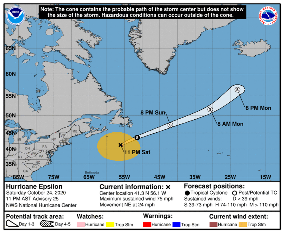
Hurricane Epsilon grew even larger as it continues to speed through the Atlantic.
The hurricane is about 400 miles south-southwest of Cape Race, Newfoundland and is headed northeast at 24 mph with 75 mph winds, according to the hurricane center’s 11 p.m. update. The hurricane increased in speed from 13 mph reported Saturday morning.
Epsilon has hurricane-force winds extending outward up to 45 miles and tropical-storm-force winds extending 380 miles, forecasters said.
Forecasters say it will possibly cause high surf and rip currents along Atlantic beaches through the weekend. There are currently no coastal watches or warnings in effect
Still, the hurricane center said Epsilon is expected to see a “acceleration” for the next day or two with some slow weakening over the weekend before turning into a “large and powerful system even after it becomes post-tropical on Sunday.”
