
 Yahoo Finance
 Wildfire updates: Winds in Northern California prompt red flag warning, fire weather watch
As more residents in El Dorado return to their homes and neighborhoods as evacuation orders are lifted, crews fighting the Caldor Fire are working to strengthen containment lines ahead of weekend winds.
In a Saturday morning incident update, U.S. Forest Service officials said that increased winds were expected starting at night and continuing through Sunday morning, with gusts up to 45 mph at ridgetops.
“Firefighters continued working to strengthen control and containment lines on Friday ahead of an anticipated change in the weather,” the Forest Service said. “Crews continue to build handline and conduct mop-up operations in the Desolation Wilderness, Convict Meadow, and Lake Margaret areas in an effort to secure the fire’s edge.”
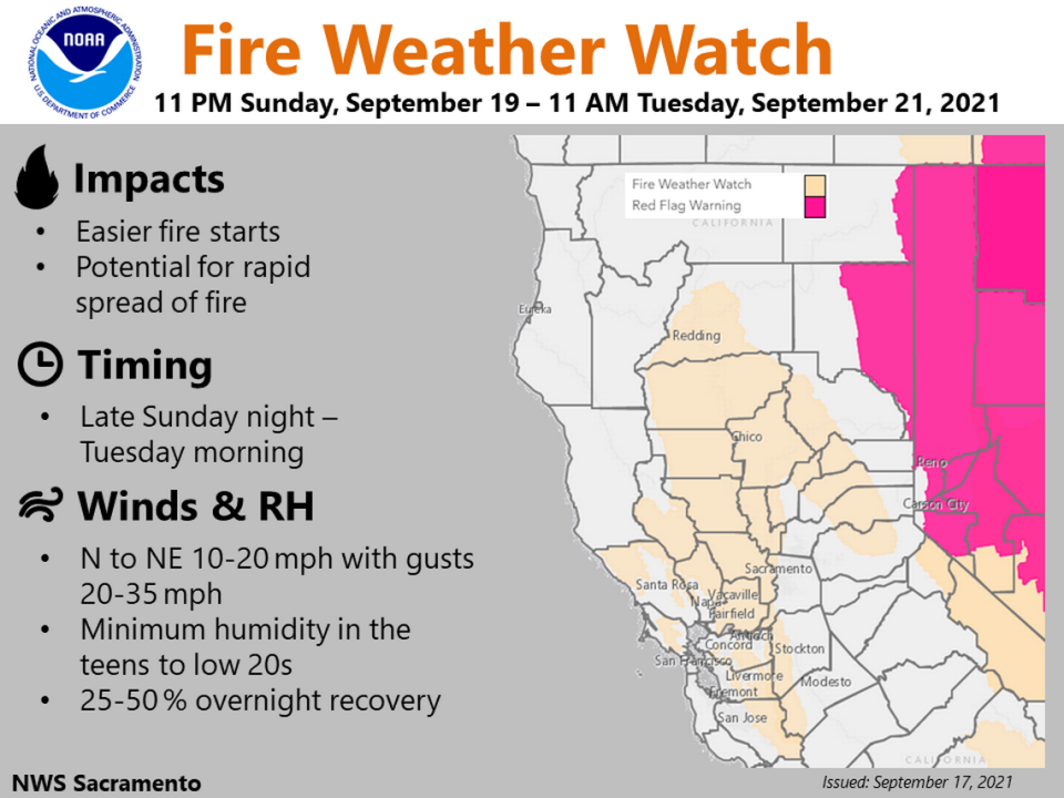
The National Weather Service’s Sacramento office predicts southwesterly winds gusting about 15 to 20 mph in Placerville and about 35 to 40 mph at South Lake Tahoe. Some light rain could accompany the winds, with up to a quarter of an inch of precipitation forecast at Kyburz.
Sacramento is expected to see less than a tenth of an inch of rain, if any.
Due to the windy conditions and the increased fire danger, the Weather Service issued a red flag warning for areas to the northeast of South Lake Tahoe — which was allowed to repopulate earlier this month — mostly in Nevada but also including the eastern half of Lassen County and the very eastern edge of Modoc County.
A fire weather watch also was issued for parts of the Sacramento Valley and Sierra Nevada, including the central areas of Placer and El Dorado counties. The fire weather watch will take effect at 11 p.m. Sunday and last through 11 a.m. Tuesday.
Crews are also working to remove trees and repair infrastructure damaged in the fire along Highway 50, which remains closed between Kyburz and Meyers, and are working along the Mormon Emigrant Trail before its reopening.
The Forest Service released a statement Friday evening to explain to the public that even though “it appears the fire no longer poses an imminent threat along the (Highway) 50 Corridor,” the highway remains closed due to public safety concerns “such as hazardous trees, utility wires, damaged and dangerous poles and other things that could pose significant injury or death.”
The Caldor Fire has burned 218,876 acres, and although it is 71% contained, Forest Service officials said that 5,465 structures are still threatened. The fire has seen lessened activity for several days. Since South Lake Tahoe’s evacuation orders were lifted Sept. 5, the fire spread by only about 3,000 acres.
Recently, crews have been able to conduct mop-up operations as far as 300 feet within the fire’s interior, according to the Forest Service. Officials expect full containment on Sept. 27.
The fire has destroyed 782 homes, 18 commercial buildings and 203 other minor structures, according to the Forest Service. The town of Grizzly Flats suffered major damage in mid-August, including the loss of several homes, an elementary school, a church and a post office, as the Caldor Fire burned through El Dorado County uncontained.
On Friday, Grizzly Flats was fully reopened by county officials, even as residents had been repopulating. Residents had been able to reenter the town starting last week with permits and proof of residency, but now all restrictions have been lifted.
Dixie Fire
The eastern area of the Dixie Fire in Lassen County falls under a red flag warning issued by the National Weather Service in effect through Saturday.
Crews working the Dixie Fire, which has burned 960,641 acres and is 88% contained, said that the increase in winds in the area could make conditions more challenging.
“These winds have the potential to make the fire more active, testing containment lines,” Forest Service officials wrote in a Saturday morning update.
Although some rain is expected Saturday afternoon along with 35-mph wind gusts, the Forest Service said that it won’t be enough to make much of a difference.
“While any precipitation is welcome, the forecasted amounts will not put the fire out but might alleviate some hot spots,” officials said in the morning incident update. “As the potential for fire activity increases due to high winds, today’s focus will be on reinforcing and holding wind-tested containment lines, as well as maintaining patrols throughout the fire perimeter and mopping up lines.”
Crews on the west side of the fire are also prepping for winds up to 25 mph, and have prepared additional resources near West Prospect Peak ahead of potentially increased activity in the area.
The Dixie Fire, the second-largest wildfire in California history, started on July 13. Earlier this week, victims sued Pacific Gas & Electric Co. over damages from the fire. Cal Fire is investigating whether the Dixie Fire was sparked by PG&E equipment.
In August, the fire burned through the town of Greenville, destroying much of it.
KNP Complex
The KNP Complex, burning in Sequoia National Park in Tulare County, is threatening the giant trees that give the park its name.
The Fresno Bee reported Saturday morning that the two fires included in the complex, the Colony Fire and the Paradise Fire, merged to create a single uncontained fire of about 18,000 acres. Some of the trees in the park have been wrapped in a special kind of fire-resistant aluminum-based foil in an attempt to protect some of the largest trees in the world. The famed General Sherman sequoia, which is the largest living single-stem tree, is among those that have been wrapped for protection along the base.
The Giant Forest grove, where General Sherman is located, is threatened by the fire’s spread. The complex is expected to burn east into the Giant Forest through the weekend, according to The Fresno Bee. One key concern for fire crews fighting the blaze is that burn scars on trees could catch fire, potentially allowing fire to burn into the interior of a tree, killing it.
Additionally, fire crews are working to protect the town of Three Rivers, located near Highway 198 and the Kaweah River, and other nearby communities.
The KNP Complex was sparked by lightning on Sept. 9.
The Fresno Bee contributed to this story.
