
 Yahoo Finance
 Weather alert: South Florida hit with strong storms as heat index soars past 100
Strong thunderstorms moved through most of South Florida Tuesday afternoon and into the evening, prompting several flood advisories throughout the region.
And rain is not over.
According to the National Weather Service in Miami, the unsettled weather pattern will continue through at least the weekend and Monday. Rain and storm chances are at 70% Tuesday and hover between 40% and 60% every afternoon for the next week.
Some of these storms could bring lightning, waterspouts and “torrential rainfall and gusty winds” and may lead to flooding.
By 12:30 p.m. Tuesday, parts of metro Broward County were under a severe thunderstorm warning, according to local meteorologists, including Miami Herald news partner CBS4.
SEVERE THUNDERSTORM WARNING in effect for portions of metro Broward county. Move indoors and stay away from windows until the storm has passed if you are in the warning area. pic.twitter.com/pdKgfOeCe6
— CBS4 Miami (@CBSMiami) August 3, 2021
The severe thunderstorm warning for Broward was quickly canceled within 30 minutes because that particular storm weakened but a flood advisory was, in turn, issued until 2:30 p.m.
That’s because heavy rain will still likely lead to flooding for areas including Coral Springs, Davie, Plantation, Sunrise, Tamarac, Lauderhill and Weston, said CBS4 meteorologist Lissette Gonzalez.
Later in the day, significant weather advisories were issued in both Miami-Dade and Broward. A flood advisory was issued for Northern Miami-Dade through 10:30 p.m.
The National Weather Service in Miami has Issued a Flood Advisory for Northern Miami-dade County in Southeastern Florida. https://t.co/Mq19LgwIo6 #flwx pic.twitter.com/Uy3jZTe2EF
— NWS Miami (@NWSMiami) August 4, 2021
Thunder roars
The ominous warnings about the week’s weather, which includes the Florida Keys but at a much lesser degree, spawned the service to post a rhyme, “When thunder roars, go indoors!”
Aug 3rd at 8:30am - Thunderstorms are in the forecast once again today across South Florida. Some of these storms could produce a significant amount of cloud to ground lighting. Torrential rainfall and gusty winds are also possible. When thunder roars, go indoors! #flwx pic.twitter.com/DXGEeLxdQK
— NWS Miami (@NWSMiami) August 3, 2021
The Keys, by comparison, are looking at the chance of isolated thunderstorms but only at 20% Tuesday and hovering around 30% to 40% for the rest of the week. But the chance of strong lightning spawned a hazardous weather outlook from the service in Key West and it applies to the island chain.
Bradenton is looking at a 60% rain chance Tuesday and 30% to 50% through the weekend, but there are no current weather alerts for the area.
The reason for the potentially rough weather?
The season is the reason. That’s the basic answer.
But, more specifically, there’s also a trough of deep tropical moisture combined with a southwesterly steering flow Tuesday and Wednesday so that is to blame for the likely storms across parts of South Florida, said CBS4’s Gonzalez.
By Thursday and Friday, a ridge of high pressure and winds shifting southeast could reduce the amount of rain in South Florida but not entirely.
Keep your umbrella close! Scattered storms will develop & some could turn strong with the potential for heavy rain, localized flooding, lightning, gusty winds & waterspouts. Stay with @CBSMiami & stay connected to https://t.co/fXLuDqHaMJ Download our free #CBS4 Weather app pic.twitter.com/7CLDROePTp
— Lissette Gonzalez (@LissetteCBS4) August 3, 2021
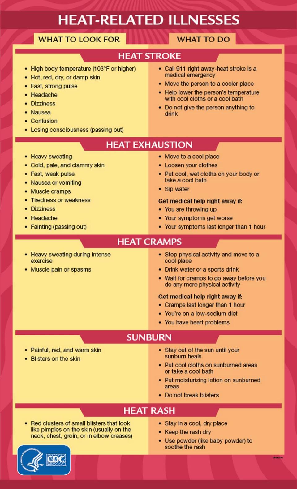
Avoid heat-related illness
Temperature-wise, the state’s continuing its broil setting on nature’s oven. Highs will hit more than 90 degrees from Miami to Bradenton and what you will really feel, the heat index, will be the 100s due to high humidity.
Hydrate and head indoors and not just for the storms. Heat stroke is nothing to mess with, but it is preventable, the Centers for Disease Control and Prevention notes.
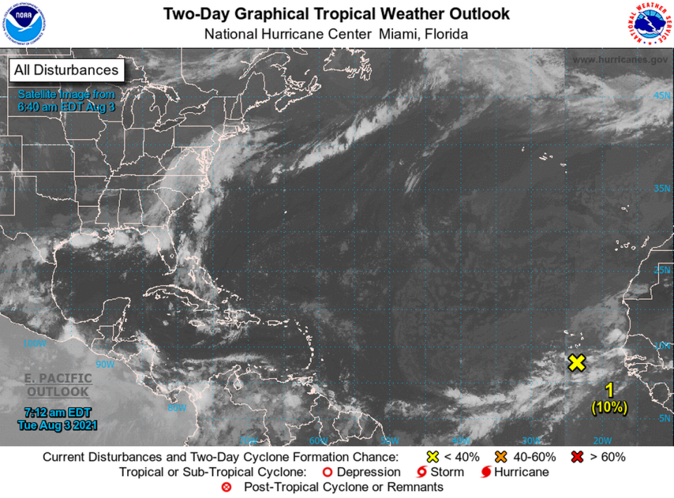
What the Hurricane Center is watching
The National Hurricane Center is monitoring a small area of low pressure that has formed about 120 miles south of Praia in the Cabo Verde Islands.
According to the 8 p.m. Tuesday alert, further development of this system, if any, should be limited to 10% through Thursday and 10% for five days, too.
The patch of thunderstorms is forecast to move in a northward or northwestward direction before hitting cooler waters by Thursday. Until then, locally heavy rainfall and gusty winds are possible over portions of the Cabo Verde Islands through Wednesday.
Miami Herald staff writer Carli Teproff contributed to this report.
