
 Yahoo Finance
 Tropical Storm Sam forms in the Atlantic. It’s expected to be a Cat 3 by the weekend
9/24/2021: Sam is now a hurricane and is forecast to rapidly intensify.
Read the original article below:
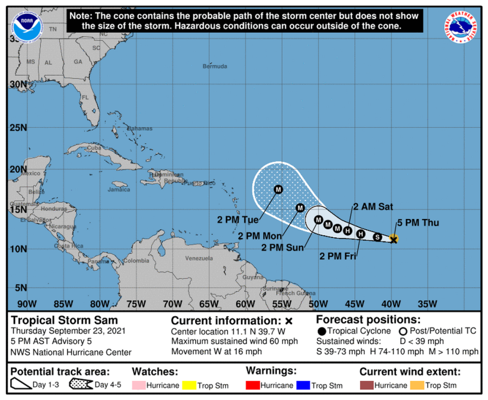
The 18th named storm of the season, Tropical Storm Sam, has formed in the Atlantic. And it’s expected to become a hurricane by Friday.
The National Hurricane Center predicts Sam will strengthen into a Category 3 on Saturday as it nears the Caribbean. Forecasters say some models suggest the storm could get stronger than forecast.
As of the 5 p.m. Thursday advisory, the system was moving west across the Atlantic at 16 mph, and its maximum sustained winds had leaped from 50 mph to 60 mph. It was about 1,635 miles east-southeast of the Northern Leeward Islands.
Listen to today's top stories from the Miami Herald:
Subscribe: Apple Podcasts | Spotify | Amazon Alexa | Google Assistant | More options
By Saturday, forecasters said Sam could have 125 mph sustained winds, which would put it close to the 130 mph winds necessary for a Category 4 storm. Around that time, forecasters expect the Sam to pump the breaks and approach the Lesser Antilles “unusually slow for a tropical cyclone.”
Models are still split on whether the storm will take a more southern or northern track as it closes in on the Caribbean over the weekend, and the hurricane center map splits the difference a bit.
In general, more powerful storms are likely to move north, because the strongest winds are usually concentrated in the northeast corner, pushing the storm north, said Athena Masson, a meteorologist and adjunct professor at Flagler College. Weaker storms don’t experience that effect as strongly, so they’re more likely to keep heading west.
The main forces pushing Sam west are large high-pressure systems to the north that block Sam’s path, Masson said. If the one closer to the U.S., the Bermuda high, moves east, Sam has an opportunity to curve north. The disagreement in the models about how far west Sam will go before turning north depends on when that high moves.
This hurricane season could see even more storms than first expected, NOAA says
What the models do agree on is that Sam will gain steam as it moves west. Sea surface temperatures in its path are high, and there’s no wind shear to tear away at the burgeoning storm.
“It’s prime conditions over the next few days,” Masson said.
The hurricane center said the storm is expected to rapidly intensify, perhaps even in the next 24 to 48 hours. Rapid intensification is a technical term that means a storm gains at least 35 mph to its wind speed in 24 hours.
Some weather watchers have noted a small plume of Saharan dust, a reliable foe of storm formation, to the northeast of Sam, but Masson said she doesn’t believe it will have an impact.
“It could maybe keep it at its strength, but I don’t think it’s necessarily going to inhibit it in the next few days,” she said.

Forecasters are also still monitoring the remnants of Odette, more than 600 miles west-northwest of the Azores.
“Showers and thunderstorms remain limited near the low, and this system has only a brief window of opportunity to become a subtropical or tropical cyclone while it moves generally south-southeastward over marginally warmer waters during the next day or so,” forecasters wrote.
The system had a 50% chance of formation in the next 48 hours and through the next five days as of the 8 p.m. update.
The hurricane center also began tracking two new disturbances on Thursday.
Need shelter this hurricane season? Miami-Dade to require masks, but not proof of vaccine
The first, a new tropical wave expected to roll off Africa’s coast this weekend and head west at 10 to 15 mph, they gave it a 30% chance of developing in the next five days.
The other one, a low-pressure area with some thunderstorms, appeared a few hundred miles south of Bermuda. Forecasters pegged its chances of development at 10% for the next two to five days. Strong winds should break this disturbance up by the weekend.
