
 Yahoo Finance
 Tempus Elizabeth Drill Holes Assay up to 23.5g/t Gold
Perth, Australia--(Newsfile Corp. - December 15, 2022) - Tempus Resources Ltd (ASX: TMR) (TSXV: TMRR) (OTCQB: TMRFF) ("Tempus" or "the Company") is pleased to announce drill assay results from the Elizabeth Gold Project in Southern British Columbia. The eleven drill-holes announced today include No. 9 Vein (EZ-22-21, EZ-22-25, EZ-22-27, EZ-22-37), South West Vein (EZ-22-30, EZ-22-31), the West/Main Vein (EZ-22-31, EZ-22-33) and the Ella Zone (EZ-22-38, EZ-22-39, EZ-22-40), see Figure 1.
HIGHLIGHTS
No. 9 Vein Intersections - Results indicate multiple zones of high grade ones within the No.9 Vein set
EZ-22-25 11.5g/t gold over 2.57 metres from 139.10 metres, including
23.5g/t gold over 0.92 metres from 139.10 metres
EZ-22-21 2.5g/t gold over 1.61 metres from 159.75 metres, including
7.8g/t gold over 0.45 metres from 160.45 metres
Assays for six No.9 Vein drill-holes remain pending including EZ-22-20 which had multiple instances of visible gold over more than 25 metres. The delay in the release of EZ-22-20 results is due to the number of over limit metallic screening assays required for samples with grades exceeding 10 g/t gold.
South West Vein Intersections
EZ-22-29 3.3g/t gold over 1.32 metres from 213.38 metres
EZ-22-30 1.5g/t gold over 0.17 metres from 124.62 metres, and 2.6g/t gold over 3.04 metres, including 6.7g/t gold over 1.10 metres from 229.15 metres
West Vein Intersections - The two West/Main Vein drill-holes reported today demonstrate the continuation of the vein structures containing gold mineralisation for approximately 220 metres south of any previous drilling increasing the strike length of the West/Main Vein Sets to approximately 400 metres
EZ-22-31 1.5g/t gold over 1.98 metres from 254.38 metres, including 2.1g/t gold over 1.15 metres from 254.70 metres, and 0.6g/t gold over 1.64 metres from 434.61 metres
EZ-22-33 1.8g/t gold over 2.20 metres from 158.8 metres, including 2.6g/t gold over 1.20 metres from 158.8 metres, and 4.3g/t gold over 1.18 metres including 9.9g/t gold over 0.51 metres from 377.67 metres
Assays for one West/Main Vein drill-hole remain pending
Ella Zone Vein Intersections - The three drill-holes completed in the Ella Zone confirm the successful discovery of a new vein set at Elizabeth
EZ-22-38 0.8g/t gold over 1.42 metres from 49.45 metres, including 1.4g/t gold over 0.49 metres from 49.81 metres
EZ-22-39 1.7g/t gold over 1.41 metres from 109.19 metres, including 2.9g/t gold over 0.66 metres from 109.19 metres
EZ-22-40 1.0g/t gold over 0.98 metres from 138.84 metres
Assays for eight drill-holes from the 2022 program at Elizabeth remain pending, including holes for No.9 Vein, Blue Vein and West/Main Vein
Tempus Resources, President and CEO, Jason Bahnsen, commented, "Today we released the assay results for eleven drill-holes that continue to show high grade mineralisation within the five individual vein sets we have under development. In addition to high grade results for the two No. 9 Vein holes we have extended the Main/West Vein set strike length by approximately 220 metres, and have confirmed the discovery of a new mineralised vein set at the Ella Zone. We have eight more holes from the 2022 drilling program that are pending assays including six additional holes from the No. 9 Vein."
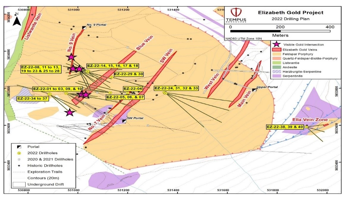
Figure 1 - Elizabeth plan view showing 2022 drill-hole locations
To view an enhanced version of Figure 1, please visit:
https://images.newsfilecorp.com/files/7585/148119_e8e4be23f465fac3_001full.jpg
No. 9 Vein Assay Results
The No. 9 vein is a vein for which its northeastern extent was mapped and initially explored via an underground adit in the early 1940's and was subject to a limited amount of historic drilling in the 1980s.
During the 2022 drill program, Tempus completed 10 drill-holes targeting potential No. 9 Vein along strike of the historical works to the southwest. Several of the No. 9 Vein drill-holes intersected wide zones of quartz veining including three drill-holes reporting the presence of visible gold.
The Company previously announced the results for drill-hole EZ-22-19 that intersected two zones of quartz veining including a 2.11 metre zone containing visible gold occurrences from 135.67 metres with assays of 87.0g/t gold over 2.11 metres from 136.11 metres, and a second zone of quartz veining over 0.50 metres from 162.92 metres.
Four No. 9 Vein drill-holes are reported. The No.9 Vein drill holes were drilled at an approximate dip angle of 65 degrees oriented broadly perpendicular to the known vein structure and No 9 Vein adit (see Figure 1 and Figure 2). The drilling and assay results indicate wide zones of previously unknown gold mineralisation to the south of the existing historic exploration adit (see Figure 2).
There are six remaining No.9 vein drill-hole assays pending including EZ-22-20 which had multiple instances of visible gold over more than 25 metres. The release of EZ-22-20 results are due to the number of over limit metallic screening assays required for samples with grades exceeding 10 g/t gold. In addition, EZ-22-28 located 100 metres along strike from EZ-22-19 and EZ-22-20 and intersected quartz veining over approximately 2.0 metres from 117.50 metres containing multiple occurrences of visible gold.
Table 1 - No. 9 Vein Assay Results
Hole ID | From (m) | To (m) | Interval (m) | True Thickness (m) | Gold Grade (g/t) | |||||
EZ-22-21 | 159.76 | 161.37 | 1.61 | 1.29 | 2.54 | |||||
including | 160.45 | 160.90 | 0.45 | 0.36 | 7.77 | |||||
EZ-22-25 | 139.10 | 141.67 | 2.57 | 2.06 | 11.49 | |||||
including | 139.10 | 140.02 | 0.92 | 0.74 | 23.54 | |||||
EZ-22-27 | 175.00 | 176.50 | 1.50 | 1.20 | 0.79 | |||||
including | 176.00 | 176.50 | 0.50 | 0.40 | 1.00 | |||||
EZ-22-37 | 182.38 | 182.90 | 0.52 | 0.44 | 0.83 | |||||
Note: True thickness is estimated using a multiplier of 0.85. | ||||||||||

Figure 2 - Elizabeth No. 9 Vein Section View
To view an enhanced version of Figure 2, please visit:
https://images.newsfilecorp.com/files/7585/148119_e8e4be23f465fac3_002full.jpg
South West Vein Assay Results
Holes EZ22-29 and EZ22-30 were drilled as in-fills, targeting the downward and north-northeast lateral extension of one of the two known mineralisation-shoots within the SW vein. EZ22-29 returned 3.27g/t Au over 1.32 m; while EZ22-30 garnered 2.58 g/t Au over 3.04 m., including 6.74g/t Au over 1.1 m. These holes raised the confidence level in this section of the SW vein. See Figure 3.
Table 2 - South West Vein Assay Results
Hole ID | From (m) | To (m) | Interval (m) | True Thickness (m) | Gold Grade (g/t) | |||||
EZ-22-29 | 213.38 | 214.7 | 1.32 | 1.12 | 3.27 | |||||
EZ-22-30 | 227.21 | 230.25 | 3.04 | 2.43 | 2.58 | |||||
including | 229.15 | 230.25 | 1.10 | 0.88 | 6.74 | |||||
Note: True thickness is estimated using a multiplier of 0.85. | ||||||||||

Figure 3 - South West Vein Section View
To view an enhanced version of Figure 3, please visit:
https://images.newsfilecorp.com/files/7585/148119_e8e4be23f465fac3_003full.jpg
West/Main Vein Assay Results
The Main Vein and the West Vein are largely unexplored and no drilling has been done to the southern extension of these vein structures.
Historic trenching at Elizabeth on the West Vein (above the West Vein underground drift) in 2003 returned 55.1g/t gold over a strike length of 20.0m and 14.2g/t gold over a strike length of 20.0m and from the Main vein (above the Main Vein underground drift). Note, historic trenching results are historic in nature and are not compliant with NI 43-101 or JORC standards and should not be relied upon and are to be used as a reference only.
In 2021, Tempus completed one drill hole (EZ-21-05) which intersected the West Vein structure with anomalous gold mineralisation 450 metres south of any historic drilling on the West/Main Vein structure.
During the 2022 drilling season, drill-holes EZ-22-24, EZ-22-31 EZ-22-32 and EZ-22-33 were advanced to test the continuity of both the West Vein and Main Vein to the south-southwest. That section of both veins is practically unexplored. Drill results show that the West and Main are not only continuing 220 metres laterally to the south-southwest but also suggest that an ore-shoot can occur to the south-southwest. Hole EZ-22-33, the furthest hole to the South West, intersected 5.89g/t (or 4.33g/t screen metallic) over 1.18 m., which include 13.00g/t (or 9.85g/t screen-metallic), over 0.51 m along Main Vein. Significant gold intersects were also noted along West Vein.
These results increase the total strike length of the gold mineralisation of the West/Main Veins to approximately 400 metres. Assay results for the third hole targeting the West/Main Vein (EZ-22-32) are pending.
Table 3 - West/Main Vein Assay Results
Hole ID | From (m) | To (m) | Interval (m) | True Thickness (m) | Gold Grade (g/t) | |||||
EZ-22-31 | 254.38 | 256.36 | 1.98 | 1.58 | 1.49 | |||||
including | 254.70 | 255.85 | 1.15 | 0.92 | 2.13 | |||||
and | 434.61 | 436.25 | 1.64 | 1.31 | 0.58 | |||||
EZ-22-33 | 158.8 | 161 | 2.2 | 1.87 | 1.82 | |||||
including | 158.8 | 160 | 1.2 | 1.02 | 2.60 | |||||
and | 377.00 | 378.18 | 1.18 | 1.00 | 4.33 | |||||
including | 377.67 | 378.18 | 0.51 | 0.43 | 9.85 | |||||
Note: True thickness is estimated using a multiplier of 0.85. | ||||||||||

Figure 4 - West/Main Vein Section View
To view an enhanced version of Figure 4, please visit:
https://images.newsfilecorp.com/files/7585/148119_e8e4be23f465fac3_004full.jpg
Ella Zone Assay Results
In 2021, Tempus completed one exploration drill hole at the Ella Zone prospect (EZ-21-21), approximately 400 metres to the southeastern extent of previously known gold mineralisation at Elizabeth. EZ-21-21 targeted quartz veining identified from 2003 trenching in the area. It returned encouraging results with up to 1.0g/t gold over 2.0m from 184.0m within a 4.0m veining zone.
Three drill-holes were included in the 2022 drilling program for confirmation of a potential new vein set. The assay results successfully made the confirmation with the presence of gold mineralisation in quartz vein widths of approximately 1.2 metres in all three holes.
Table 4 - Ella Zone Assay Results
Hole ID | From (m) | To (m) | Interval (m) | True Thickness (m) | Gold Grade (g/t) | |||||
EZ-22-38 | 49.45 | 50.87 | 1.42 | 1.21 | 0.76 | |||||
including | 49.81 | 50.30 | 0.49 | 0.42 | 1.41 | |||||
EZ-22-39 | 109.19 | 110.60 | 1.41 | 1.20 | 1.68 | |||||
including | 109.19 | 109.85 | 0.66 | 0.56 | 2.93 | |||||
EZ-22-40 | 138.84 | 139.80 | 0.96 | 0.87 | 1.04 | |||||
Note: True thickness is estimated using a multiplier of 0.85. | ||||||||||

Figure 6 - Elizabeth Veins Cross Section View
To view an enhanced version of Figure 6, please visit:
https://images.newsfilecorp.com/files/7585/148119_e8e4be23f465fac3_005full.jpg
This announcement has been authorised by the Board of Directors of Tempus Resources Limited.
Competent Persons Statement
Information in this report relating to Exploration Results is based on information reviewed by Mr. Sonny Bernales, who is a Member of the Engineers and Geoscientists British Columbia (EGBC), which is a recognised Professional Organisation (RPO), and an employee of Tempus Resources. Mr. Bernales has sufficient experience which is relevant to the style of mineralisation and type of deposit under consideration and to the activity which he is undertaking to qualify as a Competent Person as defined by the 2012 Edition of the Australasian Code for reporting of Exploration Results, Mineral Resources and Ore Reserves, and as a Qualified Person for the purposes of NI43-101. Mr. Bernales consents to the inclusion of the data in the form and context in which it appears.
For further information:
TEMPUS RESOURCES LTD
Melanie Ross - Director/Company Secretary Phone: +61 8 6188 8181
About Tempus Resources Ltd
Tempus Resources Ltd ("Tempus") is a growth orientated gold exploration company listed on ASX ("TMR") and TSX.V ("TMRR") and OTCQB ("TMRFF") stock exchanges. Tempus is actively exploring projects located in Canada and Ecuador. The flagship project for Tempus is the Blackdome-Elizabeth Project, a high grade gold past producing project located in Southern British Columbia. Tempus is currently midway through a drill program at Blackdome-Elizabeth that will form the basis of an updated NI43-101/JORC resource estimate. The second key group of projects for Tempus are the Rio Zarza and Valle del Tigre projects located in south east Ecuador. The Rio Zarza project is located adjacent to Lundin Gold's Fruta del Norte project. The Valle del Tigre project is currently subject to a sampling program to develop anomalies identified through geophysical work.
Forward-Looking Information and Statements
This press release contains certain "forward-looking information" within the meaning of applicable Canadian securities legislation. Such forward-looking information and forward-looking statements are not representative of historical facts or information or current condition, but instead represent only the Company's beliefs regarding future events, plans or objectives, many of which, by their nature, are inherently uncertain and outside of Tempus's control. Generally, such forward-looking information or forward-looking statements can be identified by the use of forward-looking terminology such as "plans", "expects" or "does not expect", "is expected", "budget", "scheduled", "estimates", "forecasts", "intends", "anticipates" or "does not anticipate", or "believes", or variations of such words and phrases or may contain statements that certain actions, events or results "may", "could", "would", "might" or "will be taken", "will continue", "will occur" or "will be achieved". The forward-looking information and forward-looking statements contained herein may include, but are not limited to, the ability of Tempus to successfully achieve business objectives, and expectations for other economic, business, and/or competitive factors. Forward-looking statements and information are subject to various known and unknown risks and uncertainties, many of which are beyond the ability of Tempus to control or predict, that may cause Tempus' actual results, performance or achievements to be materially different from those expressed or implied thereby, and are developed based on assumptions about such risks, uncertainties and other factors set out herein and the other risks and uncertainties disclosed under the heading "Risk and Uncertainties" in the Company's Management's Discussion & Analysis for the year ended September 30, 2022 dated November 14, 2022 filed on SEDAR. Should one or more of these risks, uncertainties or other factors materialize, or should assumptions underlying the forward-looking information or statements prove incorrect, actual results may vary materially from those described herein as intended, planned, anticipated, believed, estimated or expected. Although Tempus believes that the assumptions and factors used in preparing, and the expectations contained in, the forward-looking information and statements are reasonable, undue reliance should not be placed on such information and statements, and no assurance or guarantee can be given that such forward-looking information and statements will prove to be accurate, as actual results and future events could differ materially from those anticipated in such information and statements.
The forward-looking information and forward-looking statements contained in this press release are made as of the date of this press release, and Tempus does not undertake to update any forward-looking information and/or forward-looking statements that are contained or referenced herein, except in accordance with applicable securities laws. All subsequent written and oral forward-looking information and statements attributable to Tempus or persons acting on its behalf are expressly qualified in its entirety by this notice.
Neither the ASX Exchange, the TSX Venture Exchange nor its Regulation Service Provider (as that term is defined in the policies of the TSX Venture Exchange) accepts responsibility for the adequacy or accuracy of this release.
Appendix 1
Table 1: Drill Hole Collar Table
UTM | UTM | ||||||
Hole ID | Target | Easting (NAD83 | Northing (NAD83 | Elevation (m) | Length (m) | Azimuth (o) | Dip |
Z10) | Z10) | ||||||
EZ-22-01 | Blue Vein | 530953 | 5653772 | 2392 | 222.0 | 130 | -65 |
EZ-22-02 | Blue Vein | 530953 | 5653772 | 2392 | 225.0 | 108 | -65 |
EZ-22-03 | Blue Vein | 530953 | 5653772 | 2392 | 198.0 | 95 | -50 |
EZ-22-04 | Blue Vein | 531200 | 5653774 | 2393 | 375.0 | 285 | -55 |
EZ-22-05 | Blue Vein | 531130 | 5653775 | 2399 | 156.0 | 280 | -45 |
EZ-22-06 | Blue Vein | 531130 | 5653775 | 2399 | 237.0 | 290 | -55 |
EZ-22-07 | Blue Vein | 531130 | 5653775 | 2399 | 216.0 | 298 | -45 |
EZ-22-08 | Blue Vein | 531039 | 5653887 | 2422 | 201.0 | 133 | -50 |
EZ-22-09 | Blue/SW Vein | 530953 | 5653772 | 2392 | 468.0 | 101 | -53 |
EZ-22-10 | Blue Vein | 530953 | 5653772 | 2392 | 210.0 | 95 | -65 |
EZ-22-11 | Blue Vein | 531039 | 5653887 | 2422 | 207.0 | 110 | -60 |
EZ-22-12 | Blue Vein | 531039 | 5653887 | 2422 | 216.0 | 85 | -50 |
EZ-22-13 | Blue Vein | 531039 | 5653887 | 2422 | 251.0 | 123 | -65 |
EZ-22-14 | Blue Vein | 531004 | 5653896 | 2428 | 249.0 | 138 | -65 |
EZ-22-15 | Blue Vein | 531004 | 5653896 | 2428 | 240.0 | 130 | -65 |
EZ-22-16 | Blue Vein | 531004 | 5653896 | 2428 | 242.0 | 120 | -65 |
EZ-22-17 | Blue Vein | 531004 | 5653896 | 2428 | 250.7 | 160 | -65 |
EZ-22-18 | Blue Vein | 531004 | 5653896 | 2428 | 258.0 | 150 | -65 |
EZ-22-19 | No.9 Vein | 531041 | 5653893 | 2422 | 201.0 | 284 | -63 |
EZ-22-20 | No.9 Vein | 531041 | 5653893 | 2422 | 270.0 | 284 | -67 |
EZ-22-21 | No.9 Vein | 531041 | 5653893 | 2422 | 216.0 | 294 | -63 |
EZ-22-22 | No.9 Vein | 531041 | 5653893 | 2422 | 183.0 | 274 | -63 |
EZ-22-23 | No.9 Vein | 531041 | 5653893 | 2422 | 201.0 | 264 | -63 |
EZ-22-24 | West/Main Veins | 531347 | 5653777 | 2378 | 405.0 | 100 | -45 |
EZ-22-25 | No.9 Vein | 531039 | 5653888 | 2422 | 181.0 | 254 | -63 |
EZ-22-26 | No.9 Vein | 531039 | 5653888 | 2422 | 201.0 | 244 | -63 |
EZ-22-27 | No.9 Vein | 531038 | 5653891 | 2422 | 201.0 | 308 | -63 |
EZ-22-28 | No.9 Vein | 531038 | 5653891 | 2422 | 234.0 | 318 | -63 |
EZ-22-29 | SW vein | 531136 | 5653860 | 2422 | 246.0 | 111 | -48 |
EZ-22-30 | SW vein | 531136 | 5653860 | 2422 | 230.3 | 111 | -55 |
EZ-22-31 | West/Main Veins | 531351 | 5653773 | 2378 | 444.0 | 110 | -52 |
EZ-22-32 | West/Main Veins | 531352 | 5653773 | 2378 | 447.0 | 125 | -52 |
EZ-22-33 | West/Main Veins | 531352 | 5653773 | 2378 | 390.0 | 140 | -52 |
EZ-22-34 | Blue Vein | 530887 | 5653765 | 2382 | 246.0 | 120 | -55 |
EZ-22-35 | Blue Vein | 530885 | 5653769 | 2382 | 204.0 | 130 | -45 |
EZ-22-36 | Blue Vein | 530885 | 5653769 | 2382 | 210.0 | 140 | -47 |
EZ-22-37 | No.9 Vein | 530888 | 5653769 | 2382 | 201.0 | 290 | -45 |
EZ-22-38 | Ella Zone | 531917 | 5653591 | 2096 | 102.0 | 80 | -45 |
EZ-22-39 | Ella Zone | 531917 | 5653591 | 2096 | 156.0 | 110 | -60 |
EZ-22-40 | Ella Zone | 531917 | 5653591 | 2096 | 170.0 | 140 | -60 |
Table 2: Significant Interval Table
Hole ID | From (m) | To (m) | Interval (m) | True Thickness (m) | Gold Grade (g/t) | MET Screen Grade (g/t) | Vein | ||||||
EZ-22-01 | 123.9 | 124.7 | 0.8 | 0.68 | 2.07 | 2.07 | Blue Vein | ||||||
and | 125.9 | 126 | 0.1 | 0.08 | 3.82 | 3.82 | Blue Vein | ||||||
and | 161.42 | 161.82 | 0.4 | 0.34 | 2.25 | 2.25 | Blue Vein | ||||||
EZ-22-02 | 147.65 | 147.83 | 0.18 | 0.15 | 6.88 | 6.88 | Blue Vein | ||||||
and | 185.25 | 185.85 | 0.6 | 0.51 | 1.89 | 1.89 | Blue Vein | ||||||
EZ-22-03 | 96.91 | 97.33 | 0.42 | 0.36 | 2.05 | 523 | Blue Vein | ||||||
and | 124.02 | 124.47 | 0.45 | 0.38 | 32.66 | Not Performed | Blue Vein | ||||||
including | 124.02 | 124.13 | 0.11 | 0.09 | 130 | 133 | Blue Vein | ||||||
and | 164.41 | 166.14 | 1.73 | 1.47 | 7.41 | Not Performed | Blue Vein | ||||||
including | 165.41 | 166.14 | 0.73 | 0.62 | 17.4 | Not Performed | Blue Vein | ||||||
EZ-22-04 | 353.8 | 354 | 0.2 | 0.17 | 1.25 | Not Performed | Blue Vein | ||||||
EZ-22-05 | 44.5 | 45.2 | 0.7 | 0.595 | 11.2 | Not Performed | Blue Vein | ||||||
and | 56.8 | 57 | 0.2 | 0.17 | 1.38 | Not Performed | Blue Vein | ||||||
and | 84.65 | 85.55 | 0.9 | 0.765 | 1.33 | Not Performed | Blue Vein | ||||||
and | 98 | 99 | 1 | 0.85 | 2.62 | Not Performed | Blue Vein | ||||||
EZ-22-06 | 40.2 | 40.9 | 0.7 | 0.595 | 1.91 | Not Performed | Blue Vein | ||||||
and | 47.8 | 48.15 | 0.35 | 0.2975 | 1.17 | Not Performed | Blue Vein | ||||||
and | 153.35 | 155 | 1.65 | 1.4025 | 1.71 | Not Performed | Blue Vein | ||||||
Including | 154.15 | 155 | 0.85 | 0.7225 | 2.79 | Not Performed | Blue Vein | ||||||
EZ-22-07 | 164.6 | 164.92 | 0.32 | 0.272 | 1.45 | Not Performed | Blue Vein | ||||||
and | 165.66 | 165.79 | 0.13 | 0.1105 | 7.3 | Not Performed | Blue Vein | ||||||
and | 170.17 | 170.4 | 0.23 | 0.1955 | 48.6 | Not Performed | Blue Vein | ||||||
EZ-22-08 | 120.6 | 121 | 0.4 | 0.34 | 0.494 | Not Performed | Blue Vein | ||||||
EZ-22-09 | 105.12 | 106.17 | 1.05 | 0.89 | 322.54 | 310.72 | Blue Vein | ||||||
including | 105.12 | 105.32 | 0.2 | 0.17 | 1,654 | 1,572 | Blue Vein | ||||||
105.32 | 106.17 | 0.85 | 0.72 | 9.25 | 13.95 | Blue Vein | |||||||
and | 161.13 | 162 | 0.87 | 0.74 | 2.68 | Not Performed | Blue Vein | ||||||
and | 356.19 | 358.38 | 2.19 | 1.86 | 0.41 | Not Performed | SW Vein | ||||||
Including | 356.19 | 356.7 | 0.51 | 0.43 | 1.05 | Not Performed | SW Vein | ||||||
EZ-22-10 | 193.1 | 194.75 | 1.65 | 1.4 | 0.61 | Not Performed | Blue Vein | ||||||
Including | 193.98 | 194.23 | 0.25 | 0.21 | 0.997 | Not Performed | Blue Vein | ||||||
*true thickness is estimated using a multiplier of 0.85. The Company considers anything over 0.2 g/t gold as significant. **no significant intervals | |||||||||||||
Hole ID | From (m) | To (m) | Interval (m) | True Thickness (m) | Gold Grade (g/t) | MET Screen Grade (g/t) | Vein | |||||
EZ-22-11 | 102.45 | 193.42 | 91.37 | 77.67 | 0.31 | Not Performed | Blue Vein | |||||
including | 102.45 | 104.75 | 2.3 | 1.96 | 11.75 | Not Performed | Blue Vein | |||||
including | 103.15 | 103.45 | 0.3 | 0.26 | 85.2 | Not Performed | Blue Vein | |||||
EZ-22-12 | 137.65 | 139.33 | 1.68 | 1.43 | 1.26 | Not Performed | Blue Vein | |||||
including | 138.8 | 139.33 | 0.53 | 0.45 | 2.08 | Not Performed | Blue Vein | |||||
EZ-22-13 | 108.52 | 108.77 | 0.25 | 0.21 | 1.62 | Not Performed | Blue Vein | |||||
and | 111 | 111.27 | 0.27 | 0.23 | 1.03 | Not Performed | Blue Vein | |||||
and | 112.34 | 112.45 | 0.11 | 0.09 | 15.3 | Not Performed | Blue Vein | |||||
and | 196.42 | 196.6 | 0.18 | 0.15 | 1.49 | Not Performed | Blue Vein | |||||
and | 215.83 | 216 | 0.17 | 0.14 | 1.95 | Not Performed | Blue Vein | |||||
EZ-22-14 | 94.4 | 94.6 | 0.2 | 0.16 | 3.23 | Not Performed | Blue Vein | |||||
and | 156.28 | 156.51 | 0.23 | 0.18 | 1.08 | Not Performed | Blue Vein | |||||
and | 182.66 | 182.82 | 0.16 | 0.13 | 1.6 | Not Performed | Blue Vein | |||||
EZ-22-15 | 128.11 | 129.18 | 1.07 | 0.86 | 0.21 | Not Performed | Blue Vein | |||||
and | 146 | 146.57 | 0.57 | 0.46 | 0.89 | Not Performed | Blue Vein | |||||
including | 146 | 146.29 | 0.29 | 0.23 | 1.39 | Not Performed | Blue Vein | |||||
and | 186.3 | 186.85 | 0.55 | 0.44 | 1.35 | Not Performed | Blue Vein | |||||
and | 224.55 | 224.78 | 0.23 | 0.18 | 1.93 | Not Performed | Blue Vein | |||||
EZ-22-16 | 197.1 | 197.68 | 0.58 | 0.46 | 1.96 | Not Performed | Blue Vein | |||||
and | 223.2 | 224.45 | 1.25 | 1.00 | 0.76 | Not Performed | Blue Vein | |||||
including | 223.42 | 223.7 | 0.28 | 0.22 | 1.58 | Not Performed | Blue Vein | |||||
EZ-22-19 | 135.67 | 137.78 | 2.11 | 1.69 | 71.09 | 86.99 | No.9 Vein | |||||
including | 136.11 | 137.49 | 1.38 | 1.10 | 108.56 | 132.82 | No.9 Vein | |||||
including | 136.79 | 137.49 | 0.7 | 0.56 | 148.03 | 184.9 | No.9 Vein | |||||
and | 162.92 | 163.68 | 0.76 | 0.61 | 0.48 | Not Performed | No.9 Vein | |||||
EZ22-21 | 159.76 | 161.37 | 1.61 | 1.29 | 3.01 | 2.54 | No.9 Vein | |||||
including | 160.45 | 160.90 | 0.45 | 0.36 | 9.75 | 7.77 | No.9 Vein | |||||
EZ22-25 | 139.10 | 141.67 | 2.57 | 2.06 | 11.49 | Not Performed | No.9 Vein | |||||
including | 139.10 | 140.02 | 0.92 | 0.74 | 23.54 | Not Performed | No.9 Vein | |||||
EZ22-27 | 175.00 | 176.50 | 1.50 | 1.20 | 0.82 | 0.79 | No.9 Vein | |||||
including | 176.00 | 176.50 | 0.50 | 0.40 | 1.13 | 1.00 | No.9 Vein | |||||
*true thickness is estimated using a multiplier of 0.85. The Company considers anything over 0.2 g/t gold as significant. **no significant intervals | ||||||||||||
Hole ID | From (m) | To (m) | Interval (m) | True Thickness (m) | Gold Grade (g/t) | MET Screen Grade (g/t) | Vein | ||||||
EZ22-29 | 213.38 | 214.7 | 1.32 | 1.12 | 3.27 | Not Performed | SW Vein | ||||||
EZ22-30 | 227.21 | 230.25 | 3.04 | 2.43 | 2.58 | Not Performed | SW Vein | ||||||
including | 229.15 | 230.25 | 1.10 | 0.88 | 6.74 | Not Performed | SW Vein | ||||||
EZ22-31 | 254.38 | 256.36 | 1.98 | 1.58 | 1.50 | 1.49 | West/Main Vein | ||||||
including | 254.70 | 255.85 | 1.15 | 0.92 | 2.12 | 2.13 | West/Main Vein | ||||||
and | 434.61 | 436.25 | 1.64 | 1.31 | 0.57 | 0.58 | West/Main Vein | ||||||
EZ22-33 | 158.8 | 161 | 2.2 | 1.87 | 1.82 | Not Performed | West/Main Vein | ||||||
including | 158.8 | 160 | 1.2 | 1.02 | 2.60 | Not Performed | West/Main Vein | ||||||
and | 377.00 | 378.18 | 1.18 | 1.00 | 5.69 | 4.33 | West/Main Vein | ||||||
including | 377.67 | 378.18 | 0.51 | 0.43 | 13.00 | 9.85 | West/Main Vein | ||||||
EZ22-37 | 182.38 | 182.90 | 0.52 | 0.44 | 0.83 | Not Performed | No.9 Vein | ||||||
EZ22-38 | 49.45 | 50.87 | 1.42 | 1.21 | 0.76 | Not Performed | Ella Zone | ||||||
including | 49.81 | 50.30 | 0.49 | 0.42 | 1.41 | Not Performed | Ella Zone | ||||||
EZ22-39 | 109.19 | 110.60 | 1.41 | 1.20 | 1.68 | Not Performed | Ella Zone | ||||||
including | 109.19 | 109.85 | 0.66 | 0.56 | 2.93 | Not Performed | Ella Zone | ||||||
EZ22-40 | 138.84 | 139.80 | 0.96 | 0.87 | 1.04 | Not Performed | Ella Zone | ||||||
*true thickness is estimated using a multiplier of 0.85. The Company considers anything over 0.2 g/t gold as significant ** no significant intervals | |||||||||||||
Appendix 2: The following tables are provided to ensure compliance with the JORC Code (2012) requirements for the reporting of Exploration Results for the Elizabeth - Blackdome Gold Project
Section 1: Sampling Techniques and Data
(Criteria in this section apply to all succeeding sections.)
Criteria | JORC Code explanation | Commentary |
Sampling techniques |
information. |
|
Drilling techniques |
what method, etc). |
|
Drill sample recovery |
have occurred due to preferential loss/gain of fine/coarse material. |
|
| ||
| ||
Criteria | JORC Code explanation | Commentary |
Logging |
|
|
Sub- sampling techniques and sample preparation |
|
|
Quality of assay data and laboratory tests |
|
|
Verification of sampling and assaying |
|
|
Criteria | JORC Code explanation | Commentary |
Location of data points |
|
|
Data spacing and distribution |
|
|
Orientation of data in relation to geological structure |
|
|
Sample s Security |
|
|
Audits or Reviews |
|
|
Section 2: Reporting of Exploration Results
(Criteria listed in the preceding section also apply to this section.)
Criteria | JORC Code explanation | Commentary |
Mineral tenement and land tenure status |
|
(refer to ASX announcement 15 December 2020)
|
Exploration done by other parties |
|
|
Criteria | JORC Code explanation | Commentary |
Mining operations lasted six months and ended in May of 1999. During this period, 6,547 oz of Au and 17,300 oz of Ag were produced from 21,268 tons of ore. Further exploration programs were continued by Claimstaker over the following years and a Japanese joint venture partner was brought onboard that prompted a name change to J-Pacific Gold Inc. This partnership was terminated by 2010, resulting in another name change to Sona Resources Corp.
| ||
Geology |
|
Blackdome and are correlated with the Kamloops Group seen in the Ashcroft and Nicola regions. |
Criteria | JORC Code explanation | Commentary |
Geochemical studies (Vivian, 1988) have shown these rocks to be derived from a "calc-alkaline" magma in a volcanic arc type tectonic setting. Eocene age granitic intrusions at Poison Mountain some 22 kilometres southwest of Blackdome are host to a gold bearing porphyry copper/molybdenum deposit. It is speculated that this or related intrusions could reflect the source magmas of the volcanic rocks seen at Blackdome. There is some documented evidence of young granitic rocks several kilometres south of the mine near Lone Cabin Creek.
brittle faulting believed to be contemporaneous with mid- Eocene extensional faulting along the Marshall Creek, Mission Ridge and Quartz Mountain faults. |
Criteria | JORC Code explanation | Commentary |
Drill hole Information |
of the report, the Competent Person should clearly explain why this is the case. |
|
Data aggregation methods |
|
|
Relationship between mineralisation widths and intercept lengths |
known'). |
|
Diagrams |
hole collar locations and appropriate sectional views. |
|
Criteria | JORC Code explanation | Commentary |
Balanced |
Results. |
|
Other substantive exploration data |
substances. |
|
Further work |
information is not commercially sensitive. |
|

To view the source version of this press release, please visit https://www.newsfilecorp.com/release/148119
