
 Yahoo Finance
 Sonoro Extends El Colorado Zone: Reports 14.6 g/t Gold Over 1.52 Meters Within a 16.77 Meter Intercept of 1.837 g/t Gold
Figure 1
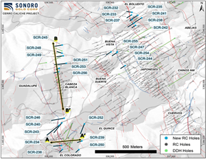
Recent Drilling Successfully Tested On-Strike and Lateral Extensions at El Colorado, Cabeza Blanca, Buena Vista and Boludito
Figure 2
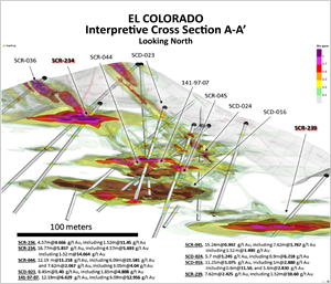
El Colorado Interpretive Cross Section A-A'
Figure 3
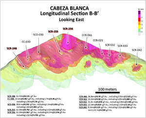
Cabeza Blanca Longitudinal Section B-B'
VANCOUVER, British Columbia, April 26, 2021 (GLOBE NEWSWIRE) -- Sonoro Gold Corp. (TSXV: SGO | OTCQB: SMOFF | FRA: 23SP) (“Sonoro” or the “Company”) is pleased to report assay results from an additional 25 RC drill holes completed at four of the 18 gold mineralized zones within the Cerro Caliche gold concession located in Sonora, Mexico. Recent drilling successfully tested on-strike and lateral extensions at El Colorado, Cabeza Blanca, Buena Vista and Boludito, as shown on the map below.
Highlights are as follows:
SCR-234 in the southern extension of El Colorado intercepted 16.77 meters averaging 1.837 grams of gold per tonne (“g/t Au”); including 4.57 meters averaging 5.627 g/t Au; including 1.52 meters averaging 14.6 g/t Au.
SCR-239 in the eastern extension of El Colorado intercepted 7.62 meters averaging 2.425 g/t Au; including 1.52 meters averaging 10.6 g/t Au.
SCR-256 at Cabeza Blanca intercepted 12.19 meters averaging 1.067 g/t Au; including 4.57 meters averaging 2.10 g/t Au; including 1.52 meters averaging 3.701 g/t Au.
SCR-247 at Buena Vista intercepted 25.91 meters averaging 0.578 g/t Au; including 3.05 meters averaging 1.784 g/t Au.
https://sonorogold.com/wp-content/uploads/2021/04/Map-Plan.png
A photo accompanying this announcement is available at https://www.globenewswire.com/NewsRoom/AttachmentNg/1c473b79-d376-47bc-b267-2283c3363edb
El Colorado Zone Expanded in Three Directions
Eight additional drill holes were completed in the El Colorado gold mineralized zone, bringing the total drilled in the zone to 22 holes and further extending the dimensions of the zone to the north, south and east. Gold bearing veins in this zone depart from the uniform northwest-prominent trend of the district and exhibit numerous splays and abrupt directional changes in the vein trends. Mineralization at El Colorado remains open in all directions and to depth.
Drill holes SCR-234 and SCR-239 both reported high grade vein intercepts. Located in the southern extension of the zone, SCR-234 reported 1.52 meters averaging 14.6 g/t Au within wider intervals of 4.57 meters averaging 5.627 g/t Au and 16.77 meters averaging 1.837 g/t Au. In the new southeastern extension of the zone and proximal to other prior high-grade intercepts, drill hole SCR-239 reported 1.52 meters averaging 10.6 g/t Au within a wider interval of 7.62 meters averaging 2.425 g/t Au. These vein intercepts may be a continuation of known veins such as the northwesterly-trending Guadalupe vein, the northerly-trending Cabeza Blanca vein, or the high-grade low angle Colorado vein identified in drill hole SCR-044 in 2018, the highest-grade drill hole completed at El Colorado. The Company plans to investigate these vein structures further in the next phase of drilling.
Veins from the El Colorado zone connect northward mainly with the Cabeza Blanca Vein zone and the Guadalupe vein. Drill hole SCR-246 located in the deep canyon between El Colorado and Cabeza Blanca shows several short connecting mineralized intervals where the Guadalupe and Cabeza Blanca veins intercept.
The image below illustrates a 300-meter cross section of selected drill holes at El Colorado.
https://sonorogold.com/wp-content/uploads/2021/04/El-Colorado-Section.png
A photo accompanying this announcement is available at https://www.globenewswire.com/NewsRoom/AttachmentNg/bf717567-ac98-45fb-8baa-7894e91fd7de
Cabeza Blanca Vein Zone Extended
Six new drill holes completed in the Cabeza Blanca gold mineralized vein zone extend the zone 50 meters to the north providing a more detailed understanding of the zone. Cabeza Blanca remains open along strike to the north and may coalesce with the El Colorado structure to the south, suggesting a continuous strike length of over one kilometer.
At the northern extension of the zone, approximately 150 meters from the bottom of Laydame Canyon, drill hole SCR-245 intercepted 1.52 meters averaging 1.990 g/t Au within a 3.05 meter-wider intercept averaging 1.118 g/t Au. The remaining five drill holes are spaced upslope to the south over a distance of 235 meters to the top of Cabeza Blanca ridge.
Highlights are as follows:
SCR-253 intercepted 12.19 meters averaging 0.792 g/t Au; including 1.52 meters averaging 2.159 g/t Au.
SCR-256 intercepted 12.19 meters averaging 1.067 g/t Au; including 4.57 meters averaging 2.10 g/t Au.
Among the six-drill holes recently completed at Cabeza Blanca, SCR-256 is the furthest south and is located approximately 35 meters north of the previously announced SCR-096 which intercepted 16.76 meters averaging 0.841 g/t Au including 4.57 meters averaging 2.419 g/t Au.
The image below illustrates a 600-meter longitudinal section of selected drill holes at Cabeza Blanca.
https://sonorogold.com/wp-content/uploads/2021/04/Cabeza-Blanca-Cross-Section.png
A photo accompanying this announcement is available at https://www.globenewswire.com/NewsRoom/AttachmentNg/c68e8c97-21ae-4219-9987-ed557a85ff3f
Drilling at Buena Vista-Japoneses Suggests Potential Coalescence with Buena Suerte Zone
Drilling at the western extension of the Buena Vista zone continues to narrow the gap between the Japoneses–Buena Vista and Buena Suerte zones. Each drill hole intercepted gold mineralization at or near surface.
Highlights are as follows:
SCR-244 intercepted 24.38 meters averaging 0.401 g/t Au.
SCR-247 intercepted 25.91 meters averaging 0.578 g/t Au; including 3.05 meters averaging 1.784 g/t Au.
SCR-254 intercepted 4.57 meters averaging 0.894 g/t Au and 9.6 g/t Ag.
Results from nine additional drill holes completed between Buena Vista and Buena Suerte are being processed for assays with results expected within ten days. The Company anticipates these drilling results to further support the potential merging of the two zones into a single body of shallow, oxide gold mineralization. If confirmed, a single larger gold mineralized zone may prove to have significant and positive economic implications for the Company’s proposed Heap Leach Mining Operation (HLMO).
Boludito Zone Extended to the North
Seven new holes drilled at the Boludito zone further confirm the zone’s mineralization as an extension of the strategically important 1.3-kilometer long Cuervos-Japoneses-Boludito gold mineralized structure. All seven holes were drilled on the northern slope of Laydame Canyon situated to the south between the Boludito and Japoneses zones. The group of drill holes indicate a general continuation of mineralization at lower gold grades with slightly higher silver content than mineralization identified south of the canyon bottom.
Highlights are as follows:
SCR-233 intercepted 4.57 meters averaging 0.721 g/t Au.
SCR-235 intercepted 7.62 meters averaging 0.402 g/t Au.
SCR-237 intercepted 10.67 meters averaging 0.629 g/t Au and 9.8 g/t Ag, including 1.52 meters averaging 2.09 g/t Au and 39.2 g/t Ag.
These drill holes represent an extension of the Boludito mineralized zone to the north of Laydame Canyon by approximately 150 meters.
Mel Herdrick, VP Exploration of Sonoro, stated, “These 25 drill holes have shown continuing expansion of gold mineralization in all four zones. The final nine drill holes assay reports arriving over the next week will show the character of the area between the Buena Suerte and Buena Vista-Japoneses zones. Surface rock in that area is strongly silicified with quartz veinlets all overprinting mylonite structures in quartzites with about one percent limonite from oxidation. I consider this intermediate area to be prospective for additional gold mineralization.”
Kenneth MacLeod, President and CEO of Sonoro, stated, “Upon the imminent receipt of the final assays for the current phase of the drill program, our database will contain over 47,500 meters of historic and recent data from 433 core and RC holes, of which 34,550 meters were drilled by Sonoro since 2018. The data will be processed by Micon International in the preparation of an updated NI 43-101 technical report and by D.E.N.M. Engineering in the preparation of a Preliminary Economic Assessment on the Cerro Caliche project. We anticipate a resumption of the drilling program in August 2021, following receipt of these reports.”
John Darch, Chairman of Sonoro, added, “These drilling results continue to affirm the potential of Cerro Caliche to host a major deposit amenable to support the proposed 15,000 to 20,000 tonnes per day Heap Leach Mining Operation (HLMO). Investors’ recognition of this potential was evident when our recent financing was over-subscribed despite being increased twice. Of Cerro Caliche’s 18 zones, this drilling focused on four different gold zones – all demonstrating significant increases in size with more high-grade gold intercepts reported in every zone. As these zones expand, many are evidencing coalescence into larger mineralized structures which would be optimal cost-wise if these multiple gold zones merge into a single major open pit mining operation. With the conclusion of the current drilling program, the development of the Cerro Caliche HLMO should accelerate as we approach critical milestones, including Cerro Caliche’s NI 43-101 resource update, its preliminary economic assessment and securing project finance for the construction and commissioning of the mine.”
Assay Results
Cerro Caliche Project, Holes Composites with Cut-off 0.15 g/t Au | ||||||||
Hole | Target | From | To | Interval | Au | Ag | AuEq | |
Meters | g/t | g/t | g/t | |||||
SCR-232 | EL BOLUDITO | 27.43 | 33.53 | 6.10 | 0.195 | 2.1 | 0.224 | |
SCR-233 | EL BOLUDITO | 27.43 | 32.00 | 4.57 | 0.721 | 7.0 | 0.821 | |
SCR-234 | EL COLORADO | 9.14 | 25.91 | 16.77 | 1.837 | 1.2 | 1.897 | |
includes | 13.72 | 18.29 | 4.57 | 5.627 | 4.7 | 5.693 | ||
including | 15.24 | 16.76 | 1.52 | 14.600 | 1.5 | 14.664 | ||
and | 65.53 | 68.58 | 3.05 | 0.207 | 0.2 | 0.210 | ||
SCR-235 | EL BOLUDITO | 9.14 | 16.76 | 7.62 | 0.402 | 1.2 | 0.420 | |
and | 68.58 | 73.15 | 4.57 | 0.159 | 0.5 | 0.166 | ||
and | 76.20 | 79.25 | 3.05 | 0.383 | 1.9 | 0.410 | ||
SCR-236 | EL COLORADO | 0.00 | 3.05 | 3.05 | 0.518 | 1.8 | 0.544 | |
and | 59.44 | 62.48 | 3.04 | 0.174 | 0.7 | 0.183 | ||
SCR-237 | EL BOLUDITO | 9.14 | 19.81 | 10.67 | 0.629 | 9.8 | 0.769 | |
includes | 13.72 | 15.24 | 1.52 | 2.090 | 39.2 | 2.650 | ||
SCR-238 | EL BOLUDITO | 47.24 | 53.34 | 6.10 | 0.208 | 0.4 | 0.214 | |
SCR-239 | EL COLORADO | 56.39 | 64.01 | 7.62 | 2.425 | 2.4 | 2.459 | |
includes | 56.39 | 57.91 | 1.52 | 10.600 | 5.0 | 10.671 | ||
SCR-240 | EL COLORADO | 12.19 | 19.81 | 7.62 | 0.419 | 2.1 | 0.449 | |
and | 59.44 | 65.53 | 6.09 | 0.357 | 2.9 | 0.398 | ||
and | 71.63 | 77.72 | 6.09 | 0.250 | 2.8 | 0.290 | ||
and | 115.82 | 124.97 | 9.15 | 0.191 | 7.5 | 0.297 | ||
SCR-241 | EL BOLUDITO | 9.14 | 13.72 | 4.58 | 0.168 | 0.8 | 0.179 | |
and | 18.29 | 28.96 | 10.67 | 0.432 | 1.2 | 0.449 | ||
includes | 19.81 | 21.34 | 1.52 | 1.665 | 4.1 | 1.724 | ||
and | 121.92 | 124.97 | 3.05 | 0.243 | 4.7 | 0.310 | ||
SCR-242 | EL BOLUDITO | 24.38 | 27.43 | 3.05 | 0.335 | 3.2 | 0.381 | |
SCR-243 | EL COLORADO | 15.24 | 19.81 | 4.57 | 0.295 | 2.7 | 0.334 | |
SCR-244 | BUENA VISTA | 0.00 | 24.38 | 24.38 | 0.401 | 5.9 | 0.486 | |
SCR-245 | CABEZA BLANCA | 7.62 | 10.67 | 3.05 | 1.118 | 0.4 | 1.123 | |
includes | 7.62 | 9.14 | 1.52 | 1.990 | 0.6 | 1.999 | ||
and | 18.29 | 22.86 | 4.57 | 0.554 | 0.2 | 0.557 | ||
and | 48.77 | 51.82 | 3.05 | 0.176 | 3.2 | 0.221 | ||
and | 68.58 | 71.63 | 3.05 | 0.267 | 2.1 | 0.297 | ||
Cerro Caliche Project, Holes Composites with Cut-off 0.15 g/t Au | ||||||||
Hole | Target | From | To | Interval | Au | Ag | AuEq | |
Meters | g/t | g/t | g/t | |||||
SCR-246 | EL COLORADO | 7.62 | 9.14 | 1.52 | 1.427 | 0.7 | 1.437 | |
and | 44.20 | 53.34 | 9.14 | 0.313 | 2.0 | 0.341 | ||
and | 68.58 | 73.15 | 4.57 | 0.413 | 9.7 | 0.551 | ||
SCR-247 | BUENA VISTA | 7.62 | 33.53 | 25.91 | 0.578 | 3.3 | 0.624 | |
includes | 16.76 | 19.81 | 3.05 | 1.784 | 13.1 | 1.971 | ||
includes | 16.76 | 18.29 | 1.53 | 2.371 | 18.5 | 2.635 | ||
and | 36.58 | 45.72 | 9.14 | 0.904 | 1.2 | 0.921 | ||
includes | 44.20 | 45.72 | 1.52 | 3.377 | 3.2 | 3.423 | ||
SCR-248 | CABEZA BLANCA | 28.96 | 36.58 | 7.62 | 0.175 | 0.4 | 0.180 | |
and | 56.39 | 64.01 | 7.62 | 0.210 | 0.2 | 0.213 | ||
and | 67.06 | 71.63 | 4.57 | 0.259 | 0.2 | 0.261 | ||
and | 76.20 | 89.92 | 13.72 | 0.535 | 6.8 | 0.633 | ||
and | 97.54 | 100.58 | 3.04 | 0.234 | 0.2 | 0.237 | ||
SCR-249 | CABEZA BLANCA | 21.34 | 22.86 | 1.52 | 1.890 | 0.5 | 1.897 | |
and | 76.20 | 91.44 | 15.24 | 0.289 | 2.3 | 0.323 | ||
SCR-250 | EL COLORADO | 19.81 | 25.91 | 6.10 | 0.240 | 1.1 | 0.255 | |
SCR-251 | EL COLORADO | 7.62 | 12.19 | 4.57 | 1.045 | 2.1 | 1.075 | |
includes | 10.67 | 12.19 | 1.52 | 1.831 | 3.0 | 1.874 | ||
and | 89.92 | 94.49 | 4.57 | 0.283 | 1.1 | 0.298 | ||
and | 100.58 | 106.68 | 6.10 | 0.276 | 1.1 | 0.292 | ||
and | 109.73 | 112.78 | 3.05 | 0.222 | 2.9 | 0.263 | ||
and | 115.82 | 120.40 | 4.58 | 0.197 | 1.5 | 0.218 | ||
and | 124.97 | 129.54 | 4.57 | 0.700 | 3.9 | 0.756 | ||
SCR-252 | CABEZA BLANCA | 16.76 | 21.34 | 4.58 | 0.280 | 0.3 | 0.285 | |
and | 25.91 | 28.96 | 3.05 | 0.374 | 0.6 | 0.382 | ||
and | 137.16 | 140.21 | 3.05 | 0.202 | 1.7 | 0.226 | ||
SCR-253 | CABEZA BLANCA | 19.81 | 25.91 | 6.10 | 0.272 | 1.5 | 0.293 | |
and | 64.01 | 76.20 | 12.19 | 0.792 | 5.1 | 0.865 | ||
includes | 67.06 | 68.58 | 1.52 | 2.159 | 2.8 | 2.199 | ||
and | 79.25 | 83.82 | 4.57 | 0.235 | 14.2 | 0.438 | ||
SCR-254 | BUENA VISTA | 0.00 | 4.57 | 4.57 | 0.894 | 9.6 | 1.031 | |
includes | 0.00 | 1.52 | 1.52 | 1.666 | 22.6 | 1.989 | ||
and | 10.67 | 15.24 | 4.57 | 0.281 | 0.4 | 0.286 | ||
and | 18.29 | 21.34 | 3.05 | 0.212 | 0.5 | 0.219 | ||
and | 24.38 | 27.43 | 3.05 | 0.517 | 0.7 | 0.526 | ||
SCR-255 | BUENA VISTA | 21.34 | 24.38 | 3.04 | 0.350 | 0.6 | 0.358 | |
SCR-256 | CABEZA BLANCA | 18.29 | 22.86 | 4.57 | 0.222 | 1.5 | 0.243 | |
and | 33.53 | 45.72 | 12.19 | 1.067 | 5.7 | 1.148 | ||
includes | 36.58 | 41.15 | 4.57 | 2.102 | 5.2 | 2.176 | ||
includes | 38.10 | 39.62 | 1.52 | 3.701 | 7.3 | 3.805 | ||
Drill collar locations, azimuths and dips for the drill holes included are provided in the table below.
Drill Collar Locations (NAD 1927 UTM Zone 12N) | |||||||
Drill Hole | Zone | Easting | Northing | Elevation | Depth (m) | Dip | Azimuth |
SCR-232 | El Boludito | 536678 | 3365650 | 1287 | 64.01 | -45 | 278 |
SCR-233 | El Boludito | 536678 | 3365627 | 1299 | 67.06 | -45 | 233 |
SCR-234 | El Colorado | 536103 | 3364453 | 1260 | 121.92 | -56 | 266 |
SCR-235 | El Boludito | 536728 | 3365624 | 1295 | 103.63 | -45 | 233 |
SCR-236 | El Colorado | 536115 | 3364416 | 1235 | 91.44 | -67 | 229 |
SCR-237 | El Boludito | 536683 | 3365588 | 1297 | 33.53 | -45 | 235 |
SCR-238 | El Boludito | 536699 | 3365556 | 1281 | 88.39 | -45 | 236 |
SCR-239 | El Colorado | 536269 | 3364491 | 1192 | 70.1 | -55 | 251 |
SCR-240 | El Colorado | 536109 | 3364656 | 1300 | 192.02 | -55 | 220 |
SCR-241 | El Boludito | 536763 | 3365599 | 1305 | 143.26 | -50 | 233 |
SCR-242 | El Boludito | 536709 | 3365533 | 1273 | 60.96 | -50 | 235 |
SCR-243 | El Colorado | 536085 | 3364632 | 1294 | 192.02 | -45 | 229 |
SCR-244 | Buena Vista | 536626 | 3365171 | 1330 | 67.06 | -45 | 234 |
SCR-245 | Cabeza Blanca | 536111 | 3365357 | 1286 | 91.44 | -45 | 258 |
SCR-246 | El Colorado | 536125 | 3364696 | 1280 | 152.4 | -45 | 260 |
SCR-247 | Buena Vista | 536560 | 3365296 | 1333 | 51.82 | -90 | 0 |
SCR-248 | Cabeza Blanca | 536111 | 3365281 | 1338 | 109.73 | -65 | 291 |
SCR-249 | Cabeza Blanca | 536121 | 3365259 | 1350 | 100.58 | -55 | 260 |
SCR-250 | El Colorado | 536246 | 3364414 | 1179 | 51.82 | -45 | 228 |
SCR-251 | Cabeza Blanca | 536148 | 3365191 | 1395 | 140.21 | -45 | 276 |
SCR-252 | El Colorado | 536291 | 3364646 | 1266 | 143.26 | -48 | 203 |
SCR-253 | Cabeza Blanca | 536088 | 3365145 | 1395 | 94.49 | -73 | 246 |
SCR-254 | Buena Vista | 536556 | 3365285 | 1333 | 70.1 | -45 | 237 |
SCR-255 | Buena Vista | 536509 | 3365293 | 1328 | 70.1 | -45 | 237 |
SCR-256 | Cabeza Blanca | 536083 | 3365112 | 1386 | 64.01 | -50 | 253 |
Quality Assurance/Quality Control (“QA/QC”) Measures and Analytical Procedures
Drill samples are collected with an airstream cyclone and passed into a splitter that divides each sample into quarters. The quartered samples are then bagged and sealed with identification. The sample group has blanks, standards and duplicates inserted into the sample stream.
Bureau Veritas (BV) collects from the drill site the samples and transports them directly to the preparation laboratory in Hermosillo, Sonora. At the preparation laboratory, a split part of each sample (about 500 grams) is reduced through crushing, splitting and pulverization. Thirty grams of each pulverized sample is split apart in the Hermosillo laboratory and undergoes a “Fire Assay” for gold content by reducing the fire assay to a concentrated button of material that is dissolved in acids and the gold content determined by atomic absorption. About another 200 grams of each sample are sent by BV to their Vancouver, Canada laboratory and dissolved there in aqua regia for multi-element ICP analysis, including silver. No QA/QC issues were noted with the results received from the laboratory.
Geologic Description
Cerro Caliche is located 45 kilometers east southeast of Magdalena de Kino in the Cucurpe-Sonora Mega-district of Sonora, Mexico. Multiple historic underground mines were developed in the concession including Cabeza Blanca, Los Cuervos, Japoneses, Las Abejas, Boluditos, El Colorado, Veta de Oro and Espanola. Mineralization types of the Cucurpe-Sonora Mega-district include variants of epithermal low sulfidation veins and related mineralized dikes and associated volcanic domes. Local altered and mineralized felsic dikes cut the mineralized meta-sedimentary rock units and may be associated with mineralization both in the dikes and meta-sedimentary rocks.
Qualified Person Statement
Stephen Kenwood, P.Geo., a Director of Sonoro, is a Qualified Person within the context of National Instrument 43-101 and has read and approved this news release. Readers are cautioned that the presence of mineralization on historic mines adjacent to or on Cerro Caliche is not necessarily indicative of economic gold mineralization in the concessions held by the Company.
Private Placement
On April 20, 2021, the company announced the closing of its oversubscribed non-brokered private placement of 17,283,586 units at $0.18 per unit, for total gross proceeds of $3,111,045. Each Unit consists of one Sonoro Common Share and one Share Purchase Warrant. Each warrant entitles the holder to purchase one additional Sonoro Common share for a period of two years from the closing date at an exercise price of $0.30 per share.
In connection with the Offering, the Company entered into finder’s fee agreements with Haywood Securities Inc. (“Haywood”), Echelon Wealth Partners Inc. (“Echelon”), Couloir Capital Securities Ltd. (“Couloir”), Canaccord Genuity Corp. (“Canaccord”) and National Securities Corp. (“National Securities”).
The Company would like to take this opportunity to clarify that it paid a total of $26,406 in Finder’s Fees, not $80,110, as incorrectly announced in the Company’s new release dated April 20, 2021. The Company also paid $9,722 in Finder’s units and 167,922 in non-transferable Finder’s Warrants.
The net proceeds from the Offering will be used principally to fund ongoing development plans at Cerro Caliche, including completion of metallurgical testing, preparation of a NI 43-101 resource update, a Preliminary Economic Assessment, in addition to property maintenance payments, and secondarily for corporate and general administrative expenses.
The Offering has received conditional acceptance from the TSX Venture Exchange but remains subject to receipt of final approval from the TSX Venture Exchange.
About Sonoro Gold Corp.
Sonoro Gold Corp. is a publicly listed exploration and development company with a portfolio of exploration-stage precious metal properties in Sonora State, Mexico. The Company has highly experienced operational and management teams with proven track records for the discovery and development of natural resource deposits.
On behalf of the Board of Sonoro Gold Corp.
Per: “Kenneth MacLeod”
Kenneth MacLeod
President & CEO
For further information, please contact:
Sonoro Gold Corp. - Tel: (604) 632-1764
Email: info@sonorogold.com
Forward-Looking Statement Cautions: This press release contains certain "forward-looking statements" within the meaning of Canadian securities legislation, relating to, among other things, the Company's plans for the exploration, development and operations at the above-described Cerro Caliche Concessions, located in the municipality of Cucurpe, Sonora, Mexico, including statements regarding the Company’s plans for additional exploration drilling, an anticipated update of the current resource estimate for Cerro Caliche to be included in a Micon International 43-101 technical report, and an independent PEA, both to be published in Q3 2021, the expectation that the planned PEA will support the Company’s mine development plans, anticipated coalescing of multiple mineralized zones, the results of pending assays, and other material conditions set out above on which the Company’s development plans are dependent. Although the Company believes that such statements are reasonable based on current circumstances, it can give no assurance that such expectations will prove to be correct. Forward-looking statements are statements that are not historical facts; they are generally, but not always, identified by the words "expects", "plans", "anticipates", "believes", "intends", "estimates", "projects", "aims", "potential", "goal", "objective", "prospective" and similar expressions, or that events or conditions "will", "would", "may", "can”, "could" or "should" occur, or are those statements, which, by their nature, refer to future events. The Company cautions that forward-looking statements are based on the beliefs, estimates and opinions of the Company's management on the date the statements are made and they involve a number of risks and uncertainties, including the possibility of unfavourable exploration and test results, unfavourable results of the contemplated PEA of the Cerro Caliche project, the lack of sufficient future financing to carry out exploration and development plans and unanticipated changes in the legal, regulatory and permitting requirements for the Company’s exploration programs. There can be no assurance that such statements will prove to be accurate, as actual results and future events could differ materially from those anticipated in such statements. Accordingly, readers should not place undue reliance on forward-looking statements. The Company disclaims any intention or obligation to update or revise any forward-looking statements, whether as a result of new information, future events or otherwise, except as required by law or the policies of the TSX Venture Exchange. Readers are encouraged to review the Company’s complete public disclosure record on SEDAR at www.sedar.com.
Neither the TSX Venture Exchange nor its Regulation Services Provider (as that term is defined in the policies of the TSX Venture Exchange) accept responsibility for the adequacy or accuracy of this release.
