
 Yahoo Finance
 Pacific Ridge Identifies New Porphyry Targets at Chuchi Copper-Gold Project
Vancouver, British Columbia--(Newsfile Corp. - December 1, 2022) - Pacific Ridge Exploration Ltd. (TSXV: PEX) (OTCQB: PEXZF) ("Pacific Ridge" or the "Company") is pleased to announce that the 2022 exploration program at the Chuchi copper-gold project ("Chuchi" or the "Project"), located 35-km northwest of Centerra Gold Inc.'s ("Centerra") Mount Milligan mine in northcentral B.C., identified several new porphyry copper-gold targets and that the BP Zone, where most of the historical drilling was focused, has room to expand. The 2022 exploration program consisted of prospecting, geological mapping, a soil sampling program and ZTEM airborne geophysical survey.
Highlights:
A moderately west-dipping stock-shaped resistivity high anomaly was identified underlying the central part of the historical BP Zone, extending from 350 m to over 1,000 m vertical depth (Figure 1).
As many as ten stock-shaped geometric anomalies in the ZTEM geophysics, representing potential porphyry centres, have been identified across Chuchi.
Two principal trends are recognized at the Project, a 10.5-km-long E-W distribution of stock-like ZTEM resistivity high anomalies and a 5-km-long N-S trend that is parallel to Valley Fault.
The E-W trend contains two new target areas, Syl-1 and Syl-2, and the N-S trend contains Klaw North, Klaw, BP Zone, and the newly identified Shoulder Zone 1.5 km south of the BP Zone.
Surface exploration results suggests that there may be additional downthrown blocks preserving the porphyry system to the south and east of BP Zone across the Valley Fault.
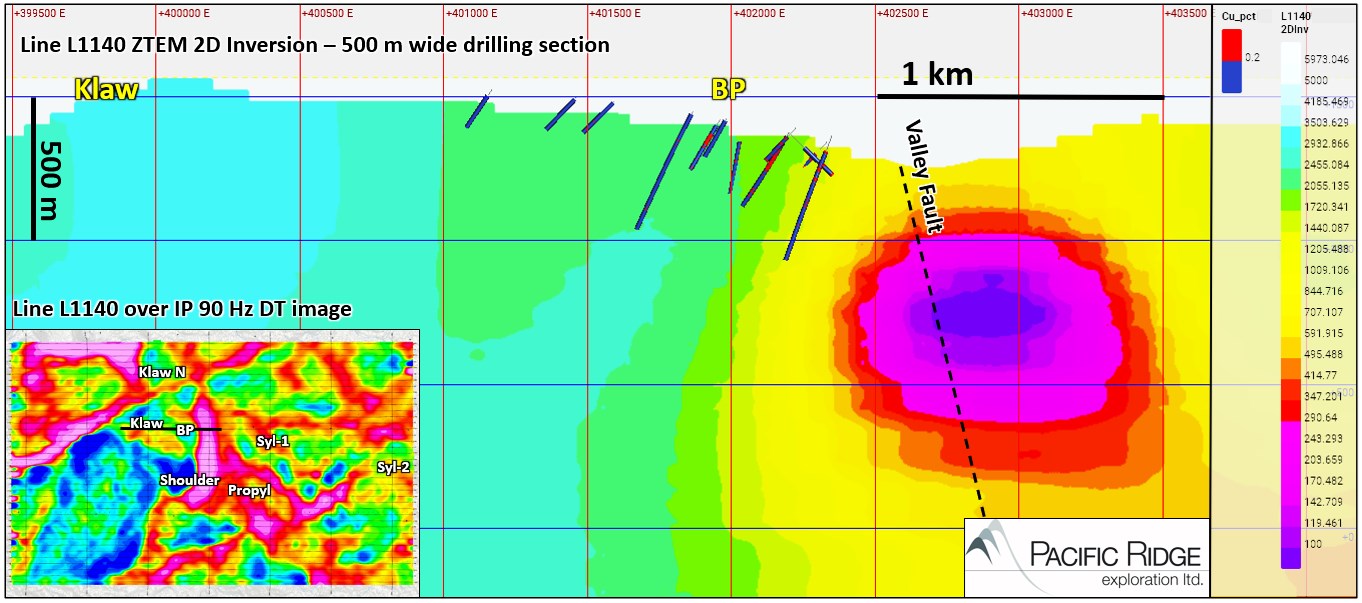
Figure 1 - ZTEM 2D Inversion Section L1140 Crossing the Southern Part of the Klaw Zone and Central Part of BP Zone. Inset Map is the ZTEM IP 90 Hz DT Map; Black Line Represents the L1140 2D Inversion Section Shown
To view an enhanced version of Figure 1, please visit:
https://images.newsfilecorp.com/files/5460/146398_57ab34e044815ab5_001full.jpg
Figure 1 is ZTEM 2D Inversion section L1140 which reveals a moderately west-dipping stock-shaped resistivity high anomaly that underlies the central-northern part of the BP Zone and extends from 350 m to over 1000 m vertical depth. It branches off a larger body of high resistivity at depth. Composite porphyry stocks at the nearby Mt. Milligan deposit are also moderately west dipping. Historical drill holes in Figure 1 (500 m wide slice) show zones of copper grade above 0.2%. Most of the historical drilling at Chuchi is shallow and has not adequately tested this stock-shaped resistivity feature at depth. The BP Zone is the most extensively explored porphyry Cu-Au target on the Project.
The ZTEM survey comprised a total of 41 east-west lines (16 km each) that were flown at 250 m line-spacing, and seven north-south tie-lines (10 km each) that were flown at 2,500 m spacing. In total, there was 726 line-km flown over 164 km2. Excellent data quality of the results is reflected in the level of detail seen in the DT (total divergence) images which compare well with the longer wavelength TPR (total phase rotated) images (see Figure 2). ZTEM is useful in mapping geology using resistivity contrasts and magnetometer data provides additional information on geology using magnetic susceptibility contrasts (Figure 3).
2D inversion cross sections were reviewed for any stock-shaped resistivity anomalies, or other geometric anomalies at the margin of resistive bodies, which were assumed to represent syeno-monzonitic Hogem Plutonic Suite intrusive rocks outboard of the batholith margin. As many as ten stocks and geometric anomalies were identified across Chuchi, including a moderately west-dipping stock-shaped feature underlying the historical BP Zone. Point locations at the top of these anomalies were projected to surface to better visualize their underlying distribution. Results show two principal trends, an east-west distribution of stock-like ZTEM resistivity anomalies that follows the trend of the TMI aeromagnetic high anomaly, and a north-south distribution parallel to Valley Fault that includes the Klaw Zone, BP Zone, and a newly identified Shoulder Zone about 1.5 km south of the BP Zone (Figure 4).
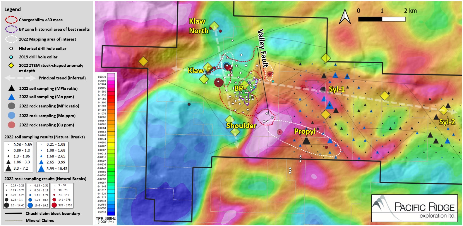
Figure 2 - ZTEM Survey Total Phase Rotation (TPR) Grid at 360 Hz
To view an enhanced version of Figure 2, please visit:
https://images.newsfilecorp.com/files/5460/146398_57ab34e044815ab5_002full.jpg
Figure 2 shows a cluster of resistivity high anomalies at the margin of the Hogem batholith underlying the Klaw, BP and Shoulder Zone porphyry target areas. The newly identified Shoulder Zone is a lobate resistivity high feature in plan and has a west-dipping stock shape starting at about 400 m depth, similar to the BP Zone feature. Newly identified target zones farther east (Propyl, Syl-1 and Syl-2) within the Chuchi Lake Succession volcanic rocks, are spatially associated with conductivity high anomalies.

Figure 3 - ZTEM Survey Total Magnetic Intensity (TMI)
To view an enhanced version of Figure 3, please visit:
https://images.newsfilecorp.com/files/5460/146398_57ab34e044815ab5_003full.jpg
Figure 3 shows the E-W linear TMI aeromagnetic high trend across the Project and aeromagnetic high anomalies associated with the BP Zone and other target areas. The Klaw Zone, adjacent to BP Zone on the northwest, has a cuspate magnetic high on its south side. Also shown in Figures 2 and 3 are the 2022 mapping areas of interest, selected 2022 rock and soil sampling geochemical results, stock-like ZTEM high resistivity anomalies projected to surface, historical chargeability anomaly (>30 msec), and historical drill hole collar locations.

Figure 4 - ZTEM 2D Inversion Section L1220 Crossing the Shoulder Zone. Inset Map is the ZTEM IP 90 Hz DT Map; Black Line Represents the L220 2D Inversion Section Shown
To view an enhanced version of Figure 4, please visit:
https://images.newsfilecorp.com/files/5460/146398_57ab34e044815ab5_004full.jpg
Highlights of the Prospecting and Mapping Program:
East of the Valley Fault, mappers encountered andesitic tuff with local equigranular syenite; the north-south oriented Valley Fault appears to juxtapose different alteration assemblages on either side.
In the southern part of Chuchi, a broad zone of propylitic-altered andesite is similar to the altered volcaniclastic rocks in the BP Zone, 2 to 4 kilometres to the north and northwest. This suggests there may be additional downthrown blocks preserving the porphyry system to the south and east of BP Zone.
In the northern part of the Project, at the Klaw Zone, mappers encountered quartz-sericite-pyrite altered andesite and monzodiorite with local chalcopyrite in outcrops (see Figure 5), potentially extending the combined BP-Klaw zone porphyry system to the north by over a kilometer.
Assay results from rocks show a cluster of high MDRU Porphyry Index (MPIx) values ranging from 1.3 to 14.5 in the Klaw Zone. These coincide with highest molybdenum (10.6-19.2 ppm), copper (141-3,710 ppm), and gold (30-222 ppb) values in the rock samples, supporting elemental dispersion proximity above a porphyry core in this area.

Figure 5 - Chuchi Project Geology
To view an enhanced version of Figure 5, please visit:
https://images.newsfilecorp.com/files/5460/146398_57ab34e044815ab5_005full.jpg
Chuchi Overview
Pacific Ridge has an option to earn up to a 75% interest in Chuchi from AuRico Metals Inc., a wholly-owned subsidiary of Centerra (see news release dated May 9, 2022). Over 8,000 ha in size, Chuchi hosts a large, well-mineralized gold-rich porphyry copper system, the BP Zone, 36 km northwest of the MBX Main deposit at Mount Milligan mine (see Figure 6). It is less than two kilometers outboard of the southeastern margin of the regional Hogem batholith (Early Jurassic phase) with related monzonitic to syenitic intrusions hosted in the Chuchi Lake volcano-sedimentary succession (Early Jurassic). The BP Zone is a 1.5 km x 1.5 km area of porphyry copper-gold mineralization surrounded by a 4 km x 3 km propylitic alteration halo (see Figure 7). Historical drilling on the project has been predominantly shallow; the average historical drill hole length is 152.2 m from 90 drill holes, and many of these drill holes bottomed in mineralization. The BP Zone has markedly similar geometry to the MBX Main deposit at Mount Milligan and is closely related to a N-S trending fault on its east side, the Valley Fault (similar to the Great Eastern Fault at Mount Milligan). The Valley Fault is thought to be a controlling structure and may vertically or laterally offset a portion of the BP Zone that remains undiscovered. Grades within the mineralized portion of the BP Zone range from 0.21% to 0.40% Cu and from 0.21 g/t to 0.44 g/t Au (see Table 1).

Figure 6 - Location of Chuchi
To view an enhanced version of Figure 6, please visit:
https://images.newsfilecorp.com/files/5460/146398_57ab34e044815ab5_006full.jpg

Figure 7 - Chuchi with Merged IP Chargeability (msec), Alteration Zones and Historical Drill Holes
To view an enhanced version of Figure 7, please visit:
https://images.newsfilecorp.com/files/5460/146398_57ab34e044815ab5_007full.jpg

Table 1 - BP Zone Historical Drilling Highlights
To view an enhanced version of Table 1, please visit:
https://images.newsfilecorp.com/files/5460/146398_57ab34e044815ab5_008full.jpg
*CuEq = ((Cu%) x $Cu x 22.0462) + (Au(g/t) x $Au x 0.032151)) /($Cu x 22.0462)
**AuEq = ((Cu%) x $Cu x 22.0462) + (Au(g/t) x $Au x 0.032151)) /($Au x 0.032151)
Commodity prices: $Cu = US$3.50/lb, $Au = US$1,750/oz.
Factors: 22.0462 = Cu% to lbs per tonne and 0.032151 = Au g/t to troy oz per tonne
Recovery is assumed to be 100%
Pacific Ridge is planning an inaugural drill program at Chuchi in 2023.
Financing Update
The Company will not be proceeding with the previously announced financing (see news release dated, November 18, 2022).
About Pacific Ridge
Our goal is to become British Columbia's leading copper-gold exploration company. Pacific Ridge's flagship project is the Kliyul copper-gold project, located in the prolific Quesnel Trough, approximately 50 km southeast of Centerra Gold Inc.'s Kemess mine. In addition to Kliyul, the Company's project portfolio includes the RDP copper-gold project (optioned to Antofagasta Minerals S.A.), the Chuchi copper-gold project, the Onjo copper-gold project, and the Redton copper-gold project, all located in British Columbia.
On behalf of the Board of Directors,
"Blaine Monaghan"
Blaine Monaghan
President & CEO
Pacific Ridge Exploration Ltd.
Corporate Contact:
Blaine Monaghan
President & CEO
Tel: (604) 687-4951
www.pacificridgeexploration.com
https://www.linkedin.com/company/pacific-ridge-exploration-ltd-pex-
https://twitter.com/PacRidge_PEX
Investor Contact:
G2 Consultants Corp.
Telephone: +1 778-678-9050
Email: ir@pacificridgeexploration.com
Neither the TSX Venture Exchange nor its Regulation Services Provider (as that term is defined in the policies of the TSX Venture Exchange) accepts responsibility for the adequacy or accuracy of this release.
The technical information contained within this News Release has been reviewed and approved by Gerald G. Carlson, Ph.D., P.Eng., Executive Chairman of Pacific Ridge and Qualified Person as defined by National Instrument 43-101 policy.
Forward-Looking Information: This release includes certain statements that may be deemed "forward-looking statements". All statements in this release, other than statements of historical facts, that address exploration drilling and other activities and events or developments that Pacific Ridge Exploration Ltd. ("Pacific Ridge") expects to occur, are forward-looking statements. Forward looking statements in this news release include plans to drill Chuchi in 2023. Although Pacific Ridge believes the expectations expressed in such forward-looking statements are based on reasonable assumptions, such statements are not guarantees of future performance and actual results or developments may differ materially from those forward-looking statements. Factors that could cause actual results to differ materially from those in forward looking statements include market prices, exploration successes, and continued availability of capital and financing and general economic, market or business conditions. These statements are based on a number of assumptions including, among other things, assumptions regarding general business and economic conditions, that one of the options will be exercised, the ability of Pacific Ridge and other parties to satisfy stock exchange and other regulatory requirements in a timely manner, the availability of financing for Pacific Ridge's proposed programs on reasonable terms, and the ability of third party service providers to deliver services in a timely manner. Investors are cautioned that any such statements are not guarantees of future performance and actual results or developments may differ materially from those projected in the forward-looking statements. Pacific Ridge does not assume any obligation to update or revise its forward-looking statements, whether as a result of new information, future events or otherwise, except as required by applicable law.
To view the source version of this press release, please visit https://www.newsfilecorp.com/release/146398
