
 Yahoo Finance
 Mountain Boy Minerals: Telegraph Assays Include 60 g/t Gold and 9.6% Copper
Geochemistry aligns with geophysics and geology on the Dok Trend
60 g/t gold with 2.3% copper in a surface sample from the Yeti Zone
9.6% copper from the Strata Gossan
Drill permit in place
Vancouver, British Columbia--(Newsfile Corp. - February 9, 2023) - Mountain Boy Minerals Ltd (TSXV: MTB) (OTCQB: MBYMF) (FSE: M9UA) ("Mountain Boy" or the "Company") reports further results from field work on the Telegraph copper-gold porphyry project in BC's Golden Triangle. These latest results continue to validate the prospectiveness of the project and to provide guidance for targeting future exploration and drilling on the property.
On the Dok Trend, which was the focus of much of the earlier work, recent soil geochemistry aligns with the geophysical targets identified in the 2022 season. Work by previous operators focused on the north end of the trend, while a separate group worked the southern part of the trend. Mountain Boy has focused on the middle of that 6-km prospective zone. In addition to the encouraging soil results, the latest rock samples contained up to 5% copper (Figure 1;Table 1). The overlapping geochemical, geophysical and geological anomalies provide compelling drill targets.
A rock sample from the Yeti Zone contained 60.5 g/t gold along with 2.3% copper. Yeti is a second target 10 km east of Dok, and has many historical surface samples with elevated gold, assaying up to 515 grams per tonne (Assessment report 21168). However, this target area has not received any systematic evaluation to date. The recent assay results (see Table 2) also include several samples with more than 1% copper as well as samples with 60.5, 18.9 and 12.2 grams per tonne gold and a sample with 1,575 grams per tonne silver.
Yeti is emerging as a highly prospective target, distinct from the Dok trend, and hosts a variety of mineralizing styles. Copper, gold and silver values have been found over an 3 km trend. In addition, the eastern part of the Yeti area hosts an Alaskan type ultramafic intrusion belonging to the Triassic Polaris Suite. Soil geochemistry over the eastern Yeti from 1990 shows elevated nickel and cobalt values over 3 kilometres. The anomaly is coincident with the ultramafic intrusion mapped by the BCGS (Mihalynuk et al., 2005). The nickel-cobalt anomaly will be followed up this season.

Figure 1 - Target Locations
To view an enhanced version of this graphic, please visit:
https://images.newsfilecorp.com/files/5332/154239_8f2b7a4264470802_001full.jpg
The Strata Gossan, a third target northeast of the Dok trend, produced a sample with 9.6% copper (Table 3), complementing a 7.7% copper value reported last year (NR, October 19, 2022). The Strata Gossan stretches 8 kms, in a northeast direction. The Strata Gossan exhibits locally intense hydrothermal alteration (sericitic) consistent with porphyry copper systems. This area was almost completely overlooked in the past and is now recognized as a third important trend on this extensive property. The area between Strata and Dok remains relatively unexplored and may represent an additional target area or possibly demonstrate continuity between what are currently interpreted as two separate target areas.
Lawrence Roulston, CEO, stated: "These latest results greatly advance our primary target area, the middle of the Dok Trend. We are seeing elevated copper values exactly where expected relative to the geophysical target. The geologic setting and style(s) of mineralization are consistent with those of the four porphyry deposits in the vicinity, which are all being advanced by majors, with one now in production. While the Yeti and Strata Gossan are not as advanced as the Dok Trend, both of these areas are also emerging as significant porphyry targets and will be further advanced this year. Results to date on the Dok Trend provide compelling drill targets for this summer."
Mountain Boy's Telegraph project spans 310 square kilometers in the northern part of BC's Golden Triangle. It is located in the Traditional Territory of the Tahltan First Nations and in the vicinity of four porphyry deposits being advanced by major mining companies. The property was consolidated through several agreements and is being examined for the first time on a consolidated basis.
Results from the Dok Trend
Early in the last field season, MTB completed a Volterra 3D Induced Polarization (3DIP or IP) survey in the central part of the Dok Trend, where sampling in the prior year identified extensive copper values at surface (NR, September 22, 2022). The western end of the annular chargeability anomaly identified by the 3DIP was followed up with 179 soil samples collected in the Red Creek area. Assays from those soil samples range from 14 to 1,651 ppm copper, 0.005 to 0.351 ppm gold and 0.6 to 65.2 ppm molybdenum. Locally, a pattern of copper enrichment occurs on the margin of the chargeability high. Figure 1 shows copper values in soil samples over the geophysical anomaly.
Work in the Dok area last year also included prospecting, mapping and sampling of other areas within the Dok trend.
Approximately 200 metres to the northwest of the historic soil grid on the Dok prospect, 77 soils were collected over 3 lines. Assays range from 35.5 to 844 ppm copper, 0.005 to 0.157 ppm gold and 1.44 to 21.3 ppm molybdenum. These lines extend the original Dok soil anomaly 1.2 kilometres in a northeasterly direction.
Roughly 2 kilometres to the southeast of the Red Creek area, 38 soil samples were collected along a contour line in the vicinity of a prominant gossan and historic soil geochemistry. Assays from the soils range from 101 to 626 ppm copper, <0.005 to 0.62 ppm gold and 1.4 to 25.2 ppm molybdenum, confirming and better defining the historic copper in soil anomaly, illustrated in Figure 2.
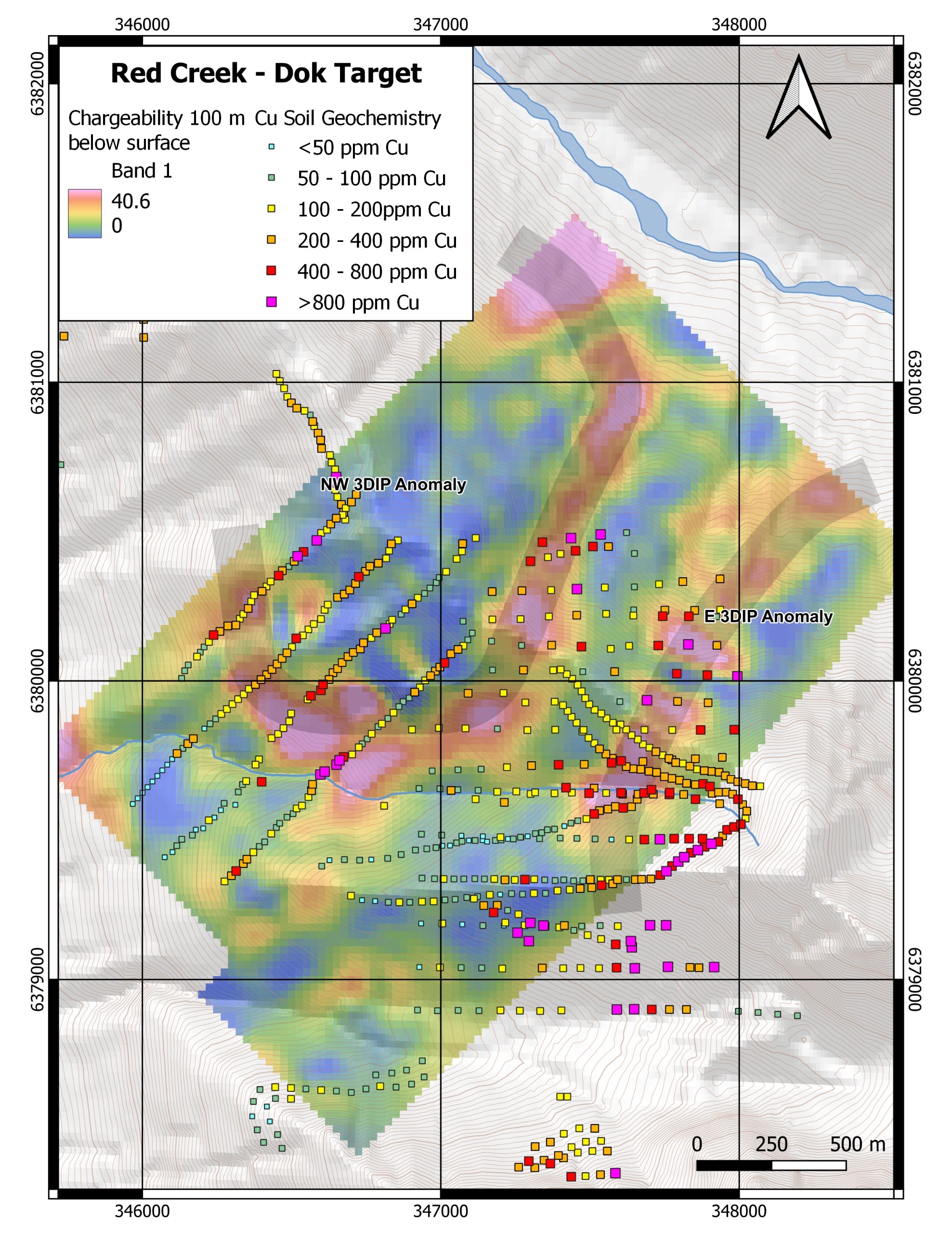
Figure 2 - Soil Geochemistry on top of 3DIP chargeability at 100m depth in the Red Creek and Border Areas
To view an enhanced version of this graphic, please visit:
https://images.newsfilecorp.com/files/5332/154239_8f2b7a4264470802_002full.jpg
Seven surface grab samples were taken from the Dok-X target. Four samples assayed greater than 0.5% copper with the highest sample yielding 3.1% copper and 0.2 grams per tonne gold. Twenty-four soil samples collected along a ridge in the vicinity of the Chuckster zone also demonstrated elevated copper in soils. Assays range from 44 to 589 ppm copper. Chuckster, located midway between Dok and Yeti, was identified in a 1962 government survey but there is no record of follow-up until the recent work by MTB.

Figure 3 - Geochemistry of the Dok-X Area
To view an enhanced version of this graphic, please visit:
https://images.newsfilecorp.com/files/5332/154239_8f2b7a4264470802_003full.jpg
Geologists also collected 31 rock samples at Chuckster, with 9 samples assaying greater than 0.5% copper with the highest being 2.6% copper and 0.44 grams per tonne gold. One sample assayed 129 ppm molybdenum with 0.13% copper and 0.36 grams per tonne gold.
Twelve samples were collected in the Nirvana South area. Samples assayed of up to 1.2% copper and 61.8 ppm molybdenum. Table 1 lists highlighted surface grab samples from the Dok trend.
Table 1: Select surface samples from the Dok Trend
SampleID | Prospect | SampType | Cu (%) | Au | Ag | Mo |
E078330 | Plum | select | 5.0 | 0.34 | 99.2 | 6.4 |
E075348 | Dok-X | grab | 3.1 | 0.22 | 40.3 | 3.0 |
B988069 | Chuckster | float | 2.6 | 0.44 | 66.0 | 3.9 |
E075273 | Chuckster | talus | 2.1 | 0.24 | 20.3 | 5.9 |
E075267 | Chuckster | grab | 1.7 | 0.21 | 17.6 | 9.5 |
E078325 | Nirvana South | talus | 1.2 | 1.2 | 0.9 | |
E075337 | Nirvana South | select | 1.0 | 0.04 | 9.7 | 4.8 |
E078331 | Dok-X | talus | 1.0 | 0.18 | 22.4 | 30.8 |
E075261 | Chuckster | grab | 0.9 | 0.05 | 16.9 | 10.5 |
B987684 | Dok-X | grab | 0.9 | 0.02 | 17.2 | 1.6 |
B988062 | Chuckster | float | 0.9 | 0.02 | 6.2 | 21.8 |
B988060 | Chuckster | grab | 0.8 | 0.10 | 8.0 | 5.5 |
E075270 | Chuckster | talus | 0.6 | 0.02 | 7.5 | 4.1 |
E078353 | Chuckster | float | 0.6 | 0.02 | 8.7 | 6.0 |
B988068 | Chuckster | float | 0.6 | 0.01 | 4.2 | 0.9 |
E078332 | Dok-X | talus | 0.6 | <0.005 | 3,344.0 | 45.6 |
E078322 | Nirvana | talus | 0.6 | 0.21 | 509.0 | 11.6 |
E078329 | Plum | composite | 0.5 | 1.32 | 2.6 | 5.0 |
B988061 | Chuckster | float | 0.4 | 0.02 | 2.2 | 9.6 |
E078326 | Nirvana South | talus | 0.4 | <0.005 | 0.2 | 3.9 |
E078327 | Nirvana South | talus | 0.4 | 0.05 | 0.7 | 2.1 |
E075265 | Chuckster | grab | 0.4 | 0.07 | 9.0 | 9.3 |
E075272 | Chuckster | grab | 0.2 | 0.01 | 2.1 | 1.9 |
E075336 | Nirvana South | grab | 0.2 | <0.005 | 4.7 | 1.6 |
E075268 | Chuckster | grab | 0.2 | <0.005 | 0.2 | 8.8 |
E075269 | Chuckster | grab | 0.1 | 0.36 | 3.2 | 129.1 |
Results from the Yeti Zone
Two lines of soil geochemistry samples were taken in the Yeti Zone. The northerly line, consisting of 38 soil samples, are anomalous in copper, gold, nickel, chromium and cobalt. The varied geochemistry is the result of an ultramafic lithological unit in fault contact with variably gossanous volcanic rocks.
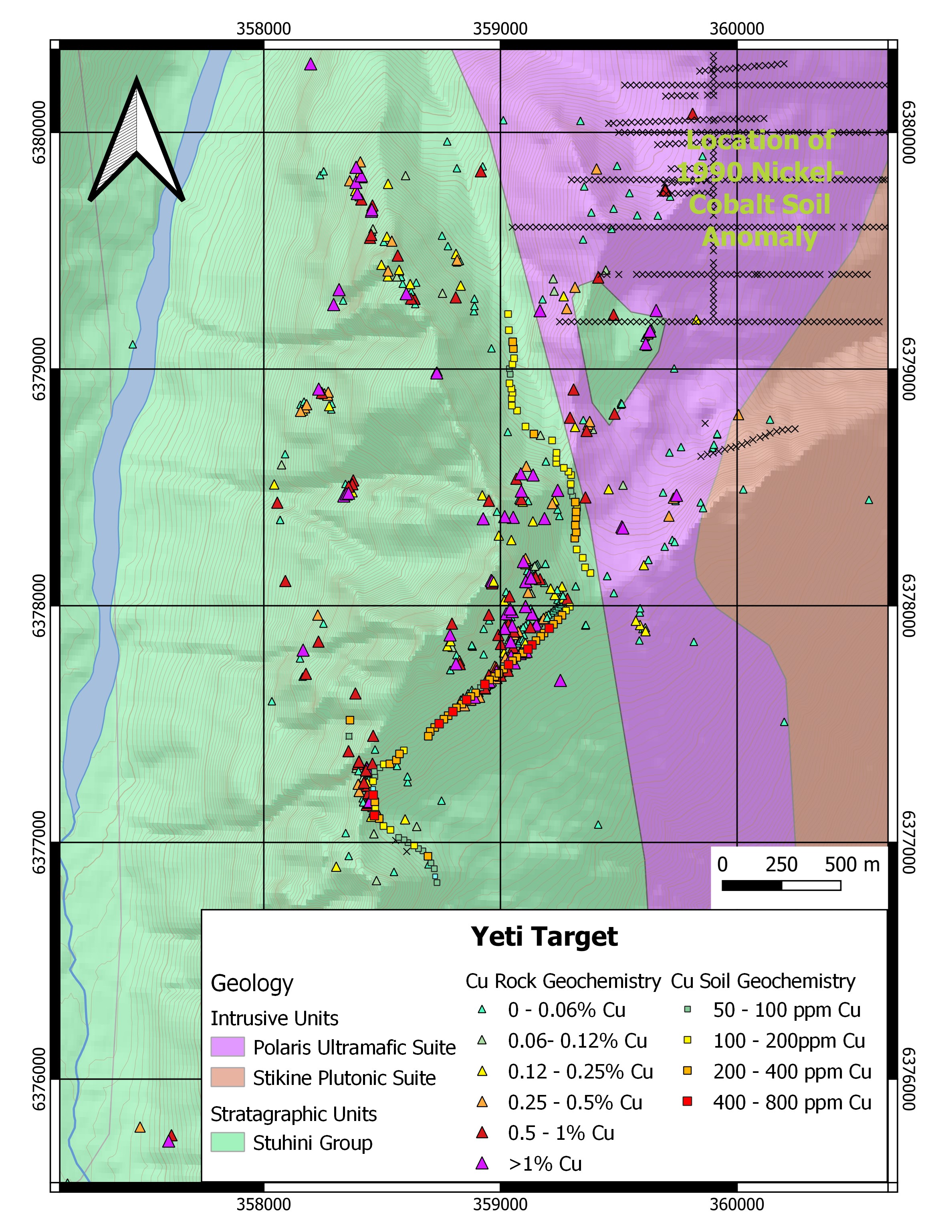
Figure 4 - Geology and Geochemistry of the Yeti Target
To view an enhanced version of this graphic, please visit:
https://images.newsfilecorp.com/files/5332/154239_8f2b7a4264470802_004full.jpg
The southerly line was a continuation of a mostly anomalous copper-gold contour soil line from 1990 and extended the copper and gold anomaly to 1.2 kilometres.
Geologists collected 26 surface rock samples with assays that yielded up to 3.5% copper, 60.5 grams per tonne gold, 1,575 grams per tonne silver, 4.4% lead, 12.6% zinc and 32.6 ppm molybdenum. Thirteen of the 26 samples assayed over 0.5% copper and 9 samples assayed over 0.5 grams per tonne gold.
Within the main Yeti Zone, the rocks feature local propylitic, silicic and K-feldspar altered intermediate to basaltic volcanic flows, welded crystal tuff and various hypabyssal phases of a composite tonalite intrusion. Mineralization occurs within quartz-carbonate-sulphide stockwork and veins containing chalcopyrite and pyrite with minor bornite, sphalerite and galena, along with localized coarse native gold. Table 2 lists highlighted 2022 surface grab samples from the Yeti Zone and Figure 3 shows the current and historic samples from the area.
Table 2: Select surface samples from the Yeti Zone
SampleID | Prospect | SampType | Cu (%) | Au | Ag | Mo |
E075292 | Yeti | grab | 3.5 | 0.51 | 351.0 | 12.2 |
B987675 | Yeti | talus | 3.4 | 0.26 | 1,575.0 | 0.8 |
B987683 | Yeti | grab | 3.0 | 0.88 | 69.5 | 1.2 |
B987676 | Yeti | select | 2.3 | 60.50 | 23.6 | 6.7 |
E078428 | Yeti | chip | 2.0 | 18.90 | 11.3 | 4.7 |
B987685 | Yeti | float | 1.7 | 1.42 | 106.0 | 9.7 |
B987680 | Yeti | select | 1.5 | 0.03 | 5.0 | 4.8 |
B987677 | Yeti | grab | 1.2 | 0.01 | 4.0 | 6.0 |
E075288 | Yeti | grab | 1.1 | 4.14 | 8.5 | 5.9 |
E075291 | Yeti | grab | 1.0 | 0.83 | 76.9 | 29.7 |
E078430 | Yeti | float | 0.9 | 0.02 | 4.3 | 8.8 |
E075289 | Yeti | grab | 0.9 | 12.20 | 3.4 | 7.8 |
E078427 | Yeti | select | 0.7 | 1.9 | 1.4 | |
E075343 | Yeti | grab | 0.7 | 0.17 | 1.8 | 32.6 |
E078324 | Yeti | grab | 0.6 | 0.61 | 2.2 | 11.2 |
E075347 | Yeti | select | 0.4 | 0.05 | 3.1 | 2.4 |
E075344 | Yeti | grab | 0.3 | 0.02 | 0.8 | 1.4 |
E075342 | Yeti | grab | 0.3 | 0.03 | 0.9 | 23.7 |
E075287 | Yeti | grab | 0.2 | 0.24 | 1.2 | 9.0 |
E075290 | Yeti | grab | 0.1 | 0.02 | 18.0 | 6.3 |
E075345 | Yeti | grab | 0.1 | 1.47 | 0.5 | 2.7 |
Results from Strata Gossan
The Strata Gossan extends for over 8 kilometres, beginning 2 kms north of Dok. The gossan results from the oxidation of pyrite, and is interpreted to be the footprint a hydrothermal system related to an underlying porphyry. Geochemistry results from both the soil and the rock samples suggest that the alteration within the gossan may represent the upper portion of a porphyry system. Mineralized veins crosscut the gossan, producing local copper and gold anomalies.
A total of 125 soil samples were collected along three contour lines in the Strata Gossan area. Assays ranged from 31 to 1,604 ppm copper, <0.005 to 0.056 ppm gold and 1.7 to 25.1 ppm molybdenum. Another 7 rock samples were also collected with two samples assaying over 1% copper. Table 3 lists highlighted surface grab samples from the Strata Gossan.
Table 3: Surface samples from the Strata Gossan
SampleID | Prospect | SampType | Cu | Au | Ag | Mo |
B987713 | Strata | grab | 9.6 | 0.03 | 40.9 | 7.7 |
E078429 | Strata | float | 1.3 | 0.04 | 16.3 | 1.4 |
E075327 | Strata | grab | <0.1 | 0.01 | 0.4 | 5.5 |
E075284 | Strata | grab | <0.1 | <0.005 | 0.2 | 3.7 |
E075330 | Strata | grab | <0.1 | 0.05 | 0.8 | 3.3 |
E075329 | Strata | grab | <0.1 | 0.04 | 0.5 | 17.7 |
E075328 | Strata | grab | <0.1 | <0.005 | 0.1 | 4.1 |
Results from the Plum Area
The Plum area was identified in a 1990 provincial government survey but there was no recorded follow-up. Five samples taken last fall returned assays of up to 5.2% copper, 1.4 grams per tonne gold and 106 grams per tonne silver. The Plum area is on a gossanous ridge between the Strata Gossan and Yeti. The alteration footprint is visually similar to that of the Strata Gossan. Table 4 lists highlights from the Plum area. These results suggest yet another target area.
Table 4 - Surface samples from the Plum Area
SampleID | Prospect | SampType | Cu | Au | Ag | Mo |
E078330 | Plum | select | 5.0 | 0.34 | 99.2 | 6.4 |
B987685 | Plum | float | 1.74 | 1.42 | 106.0 | 9.7 |
B987683 | Plum | grab | 3.03 | 0.88 | 69.5 | 1.2 |
B987682 | Plum | float | 5.16 | 1.30 | 89.9 | 1.6 |
E078329 | Plum | composite | 0.51 | 1.31 | 2.6 | 5.0 |
Lucia Theny, VP Exploration summed up the latest results: "We are making progress in understanding this intricate geological system. The multiple mineralizing phases create geological complexity but also produced extremely well-mineralized and potentially overlapping systems. Over the next few months, the geological team will integrate these latest results with the results of work by previous operators. We are also employing various advanced scientific techniques to extract as much information as possible, particularly with respect to hydrothermal alteration and trace element geochemistry. Over the coming weeks, we will be working to determine the next steps as we systematically advance toward a drill program, planned for this summer."
The Telegraph project is permitted for drilling. Logistical arrangements are being implemented for a program that is set to begin this summer.
About Mountain Boy Minerals
Mountain Boy has six active projects spanning 670 square kilometres (67,587 hectares) in the prolific Golden Triangle of northern British Columbia. With the focus on the Telegraph project, discussions are now underway with entities leading to joint ventures and/or spinouts of other projects.
The American Creek project is centered on the historic Mountain Boy silver mine and is just north of the past producing Red Cliff gold and copper mine (in which the Company holds an interest). The American Creek project is road accessible and 20 km from the deep-water port of Stewart.
On the BA property, 182 drill holes have outlined a substantial zone of silver-lead-zinc mineralization located 4 km from the highway.
Surprise Creek is interpreted to be hosted by the same prospective stratigraphy as the BA property and hosts multiple occurrences of silver, gold, and base metals.
On the Theia project, work by Mountain Boy and previous explorers has outlined a silver bearing mineralized trend 500 metres long, highlighted by a 2020 grab sample that returned 39 kg per tonne silver (1,100 ounces per ton).
Southmore is in the midst of some of the largest deposits in the Golden Triangle. It was explored in the 1980s through the early 1990s and was overlooked until Mountain Boy consolidated the property and confirmed the presence of gold and copper, with values up to 20% copper and 35 g/t gold.
Recent field program on the Telegraph project has provided compelling evidence for the presence of a cluster of porphyrys. The 310 square kilometre Telegraph Project is located in the vicinity of several large porphyry deposits including Galore Creek (Teck - Newmont), Schaft Creek (Teck - Copper Fox), Big Red (Libero Copper and Gold), Saddle and Saddle North (Newmont) and the operating Red Chris copper-gold mine (Newcrest - Imperial Metals).
The technical disclosure in this release has been read and approved by Andrew Wilkins, B.Sc., P.Geo., a qualified person as defined in National Instrument 43-101.
On behalf of the Board of Directors:
Lawrence Roulston
President & CEO
For further information, contact:
Caroline Klukowski
info@mountainboyminerals.ca
NEITHER TSX VENTURE EXCHANGE NOR ITS REGULATION SERVICES PROVIDER (AS THAT TERM IS DEFINED IN THE POLICIES OF THE TSX VENTURE EXCHANGE) ACCEPTS RESPONSIBILITY FOR THE ADEQUACY OR ACCURACY OF THIS RELEASE.
This news release may contain certain "forward looking statements". Forward-looking statements involve known and unknown risks, uncertainties, assumptions and other factors that may cause the actual results, performance or achievements of the Company to be materially different from any future results, performance or achievements expressed or implied by the forward-looking statements. Any forward-looking statement speaks only as of the date of this news release and, except as may be required by applicable securities laws, the Company disclaims any intent or obligation to update any forward-looking statement, whether as a result of new informationuture events or results or otherwise.
To view the source version of this press release, please visit https://www.newsfilecorp.com/release/154239
