
 Yahoo Finance
 Messy storms target Ontario with no consistent cold in sight
Although a dangerously cold shot of Arctic air swept through southern Ontario last week, it was gone just as quickly as it arrived, with much milder temperatures flooding back into the region this week. Some areas may even have a brush with double digits on Tuesday.
MUST SEE: Three things that made the Eastern Canada cold snap so bizarre
But with a big temperature swing, often comes some unsettled skies, and this surge of milder air will bring widespread messy precipitation this week.
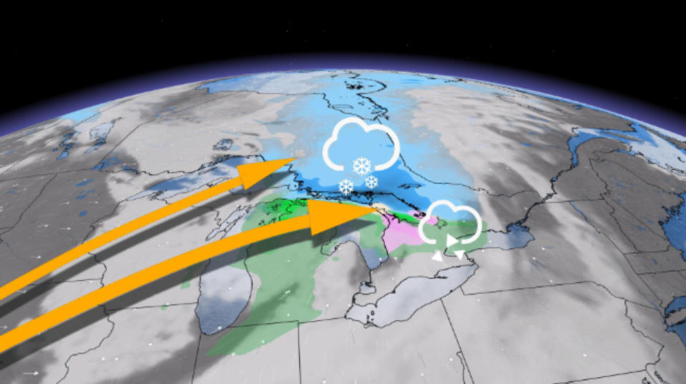
A weak system moving in on Tuesday is bringing the risk of rain, freezing rain and periods of snow to the north.
The freezing rain will mainly be confined to the higher elevations of the escarpment, but with less than 2 mm expected. Therefore, the threat of slippery conditions is pretty minimal.

There is the threat of very patchy freezing rain as far south as Highway 401 near London and Kitchener, and as well as central and eastern Ontario.
For the rest of southern Ontario however, most of the precipitation will stay as rain showers, but again, will remain very light with most the day staying dry.
Farther north in the Nickel Belt and cottage country, between 5-10 cm of snow is possible, especially in areas that pick up a little extra moisture from Lake Huron. Amounts could top 10 cm in some areas north of Georgian Bay.

Strong winds will also accompany the system, with gusts between 50-70 km/h widespread throughout southern Ontario and even stronger gusts of 70-80+ km/h on the escarpment.
Watching a Texas low for Thursday
A Texas low on Thursday will draw up a warmer, moist flow from the U.S. deep south. With so much warm air aloft, there's a risk of freezing rain across the higher terrain of southern Ontario.
Temperatures will soar into the mid-teens in Ohio, but it remains to be seen how far north the warm front tracks. Double digit temperatures are possible in the Windsor area in the warm sector of the storm.
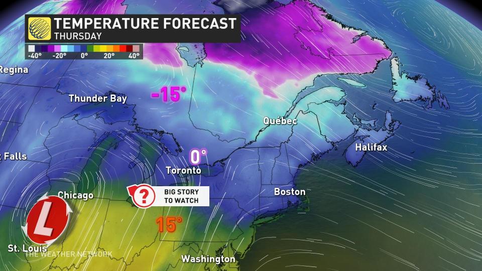
Double digit temperatures are possible in the Windsor area in the warm sector of the storm, while places like Toronto could very well be stuck in a chilly flow off the lake.
Forecasters are also closely watching a system that could clip the region with some snow Friday night and into Saturday, though it's also possible that the system stays too far south to impact the region.
RELATED: Mild winter pattern brings more rain than snow in parts of southern Ontario
Very mild temperatures will dominate next week, remaining unsettled at times with the risk for more rain. There is the potential for a more wintry pattern during the final ten days of the month, but with no persistent cold in place.
Check back for the latest weather updates across Ontario this week.
